Townsville to Gold Coast Anchorages and Moorings

Cape Bowling Green Anchorage (Bowling Green Bay)

This anchorage has no shelter from the wind and sits behind a low-lying sand spit. Anchorage is quite shallow with good holding in sand. We anchored in 4 metres of water with 20+ knots SE winds.

Cape Upstart Anchorage (Shark Bay)

Sheltered anchorage behind the Cape, opposite the onshore conservation building. Good holding in sand, the anchorage is well sheltered for anything from south west to south east.

Cape Gloucester Mooring

There are a number of moorings available here and these can be hired for $25.00 per night. Pay at Gloucester Bay Resort bar. You’ll need to provide the name of your boat, boat registration number and the number of the mooring ball you are using or intend to use. A few boats also anchored behind the mooring field. Beach access via tender is easy at all tide levels.

Gloucester Bay Resort

Hook Island

Stonehaven Bay Mooring

There are 12+ moorings scattered around the bay. (More moorings than noted on Navionics). Most are Marine Park green buoys. A nicely sheltered and well protected mooring field. If you are not lucky enough to get a mooring, anchoring is a feasible option. Just be aware of fringing reef near the beach.

Luncheon Bay Mooring

As of September 2024, five moorings were available in the bay (4 green and 1 blue). It was quite a rolly anchorage/mooring in a south easterly wind.

Butterfly Bay Mooring

Quite a few moorings are available in this bay. The bay is reasonably sheltered but subject to swell and chop from SE – E winds. We only stayed till mid afternoon and moved due to the mooring buoy consistently banging on the hull. We ended up back at Stonehaven Bay for a couple of nights.

Whitsunday Island

Apostle Bay Anchorage

Good holding in sand. Very calm, no swell and lots of turtles. Well protected from south-south easterly winds; not recommended for any winds with a northerly aspect.

Whitsunday Island

Tongue Bay Mooring Field

Highly competitive for moorings here, including tourist and charter boats. Very good mooring field with a range of mooring sizes available. Beach is primarily rock, and at low tide you must follow the channel markers. There is limited space to haul dinghies up the beach, particularly so when tourist boats are loading and unloading passengers.

Haslewood Island Mooring (Chalkies Beach)

Good mooring area, well protected from south to north easterly winds. Again very popular spot with cruisers and tourist operators. Good beach access, with a nice reef close to shore.

Snorkelling Whitsunday

Lindeman Island Anchorage

Very good holding in mud. (We held well during a squall with 30+ knot winds). The anchorage is exposed from south westerly to easterly winds. There is a reef jutting out from the beach as well as inshore submerged rocks so take care when accessing the beach.

Thomas Island Anchorage

There are only a couple of moorings here, and both were taken so we anchored in the channel between Thomas and Long Islands. Good holding in sand in 6 metres of water just off the north eastern beach. No issues with beach access.

North Queensland Islands

Brampton Island Anchorage

Good holding in sand, and well sheltered from swell but not from wind. Bay shallows quickly. Probably only enough room for 3 boats in Maryport Bay.

Scawfell Island Anchorage

You may be fortunate enough to get a mooring here, but they are in high demand. We anchored here for three nights, and a number of boats did not adhere to the 24 hour mooring limit i.e they were there when we arrived and were still there when we left.

We anchored on the right hand side of Refuge Bay close to the ‘no anchor’ area. Holding was good in 20 – 30 knots of wind. Semi-sheltered but subject to swell wrapping around the island causing a rolly anchorage. In hindsight, the left hand side of the bay may have been a better option.

Middle Island (Percy Group) Anchorage

West Bay is a fairly small bay with room for about four yachts comfortabley. Good holding in sand, but subject to swell from south and north. It is a popular anchorage as it is the base for the famlous ‘Percy Island Yacht Club’.

North Queensland

Great Keppel Island Anchorages

Inititially we anchored at Long Beach bay to shelter from northerly – north westerly winds. When we arrived there were about 35 – 40 vessels in the bay. The anchorage would be suitable for northerly through to north easterly winds. Good holding in sand. Not recommended for wind or swell with a southerly aspect as it is very rolly.

We moved around the corner to Monkey Bay the next morning to gain greater shelter from predicted easterly winds. Sandy bottom, and good holding in five metres of water. Room for 7 – 8 vessels to anchor here. There are also two moorings in the bay which are hugely popular. Monkey Bay is a short dinghy ride from the island bar and bistro.

Islands of North Queensland

Lady Musgrave Island Anchorage

The entry channel to the lagoon is quite narrow, 10 – 12 metres but clearly marked. Important note: the channel markers are NOT lit at night. The lagoon has coral bombies scattered throughout, and we would recommend entering between mid morning and mid afternoon so that you can easily identify where the bombies are.

Lady Musgrave is a very popular destination, there were 18 boats when we arrived and more came in afterwards. Knowing that there was only six moorings available, we knew coming in that it was highly unlikely that we would score one of these. And we were right. That said there are plenty of anchoring options within the lagoon. We anchored in 8 metres of water in a reasonably clear patch. Good holding in sand.

Bribie Island Anchorage

Good holding in sand on the side of the chennle just north of the jetty. Be sure to leave enough swing room, as the current is quite strong and you will experience wind against current. Easy access to the shore by dinghy, tie off the jetty pontoons.

Deanbilla Bay (North Stradbroke Island) Mooring

Picked up a mooring ball on the southern end of the bay with no problems.

Perrys Hole Anchorage (next to Crusoe Island)

Good holding in sand but subject to strong current flows. Warning – Lots of midges and mosquitos here.

The Broadwater (Gold Coast)

We anchored at Currigee on South Stradbroke Island. A popular abchorage spot with good holding on the side of the main channel. Quite strong currents noted. This channel should actually be renamed ‘Hoonsville’! From sunrise to post sunset we bounced around due to the number of boats large and small as well as jet skiers passing at speed, super close at times. Runaway Bay Shopping Centre is across the Broadwater, easy access with a dinghy dock available.

Mackay Marina

Location: Mackay, Queensland

Duration: 2 weeks

Cost: $459.00* per week for a catamaran berth inclusive of electricity and water.

Mackay Australia

Staffing: Friendly and helpful marina staff are available onsite Monday – Sunday 0830 – 1630. Marina staff are happy to assist not just with marina queries, but also the township, transport and the like. Docking assistance is not available at this marina.

On checking in we received a Welcome Pack inclusive of: printed Marina Information, Amenities and Environmental Policy; Marina Rules; Listing of Local Services; Marina Berth and Amenities Map; Marina Shipyard Price List and Contact Details; local Tide Chart; Public Bus Schedule and a Town and Regional map.

Security: There are no dedicated security staff at this marina. Access to each section of the marina is via a solitary gate which is activated by a fob. (Fobs are provided on check in at the marina office. $50.00 deposit per fob required).

Lights as part of each berth pedestal in our area of the marina were inactive for most of the time we stayed at the marina, creating an unnecessary security, and health and safety risk.

Parking: There is no designated marina parking area in place, general street parking is nearby.

Amenities: Two separate male and female shower/toilet blocks are available for use by marina berth holders, access via fob. Both blocks are functional but old and dated. Supposed to be renovated late 2024, but as of the end of October there was no sign of any work commencement.

A laundromat is available 24 hours each day and is located behind the marina office. Washing machines require 6 x $1.00 coins per load, dryers 6 x $1.00 coins per 6 minutes of drying time. Rubbish dumpsters are located near the ablutions.

Transport: Courtesy cars, Rent-A-Bomb, are available at this marina, book at the marina office. Morning, afternoon or evening hire is available for $30.00, $59.00 for full day hire. Other transport options include public bus, taxi, Uber, hire car.

Wifi: Free wifi is available 8.30 – 4.30 each day upstairs in the marina office.

Noise: We didn’t experience any noise issues while at this marina.

Hard stand and haul out facilities: are available at this marina. Contact and pricing details are provided as part of the marina Welcome Pack provided on check in.

Fuel: a fuel dock is in place as you enter through the breakwater – pay by credit card or if you are staying at the marina fuel costs can be added to your account.

Gas: Swap & Go gas bottles are available at the marina office.

Shops/Chandlery: The marina office has a limited range of chandlery supplies as well as basic domestic supplies and clothing for purchase.

Tidal movement in this part of the world is crazy.

Check out the dock at low tide, getting up the ramp to land is a work out in itself.

North Queensland Low Tide

A small range of eateries including a pub, take away fish and chip/pizza shop, café and steak restaurant are located next to the marina office. Other eateries and pubs are located in central Mackay and will require transport to access.

There is a large-ish shopping centre, Caneland, located within the town of Mackay. Bunnings, Aldi, Road Tech Marine and the like are further out.

Overall, we rated this marina 6/10.

*Prices are correct at time of stay.

Townsville to Gold Coast

Duration: 56 days

After refuelling we departed Breakwater Marina Townsville on the 23rd  of September initially retracing our route through Townsville waters for an overnight stay at Magnetic Island. Though this trip, we approached the island from the south side. Passenger and car ferries as well as small cargo ships dock at Nelly Bay on this side of the island. Lots of accommodation and resorts here (high rise apartments and cute chalets) as well as a small marina. We continued along the southeast coastline passing Bremner Point with huge rock formations, Alma Bay next door, then Florence and Radical Bays which we saw from the land side on our previous visit here. As we continued motoring towards Horseshoe Bay and with the wind in our favour, we took the opportunity to bring the headsail down. We noticed a hole on the luff a few weeks back which has been getting progressively bigger. So once anchored, and until we can organise a replacement sail, Peter took the opportunity to get his sewing kit out and patched it. Nice job too.

North Queensland

We were up at 0530 to prep for our trip out to Wheelers Cay for some snorkelling. Though very quickly we were being hit by strong 18+ knot winds, and a strong head on chop. By 0900 Peter decided to abandon the trip to Wheelers Cay, as it would not be suitable for snorkelling in these conditions. So, we changed course southward, unfortunately for us the sea and wind conditions continued to be challenging. We passed Cleveland Point and Mount Cleveland before finally anchoring for an overnight stay at ……. Cape Bowling Green in Bowling Green Bay. Where do they get these names!! A long skinny flat sandy cape which stretches in a shallow arc. And to the naked eye it is so flat one could liken it to a bowling green. Strong ESE winds continued overnight, but the anchor held which was the most important thing.

Another early start saw us upping anchor at Bowling Green Bay to face another day of crappy washing machine seas and strong ESE winds (up to 20 knots). Around the top of the Cape conditions didn’t improve, as a 1.5 – 2 metre swell was running, initially head on. It was a long and at times uncomfortable motor-sail, until we finally anchored in Shark Bay at Cape Upstart right in front of huge heavily vegetated hills, just gorgeous. Houses were sporadically clustered in two’s and three’s along this part of the bay. By sunset a number of other boats had joined us in the bay, no doubt taking shelter from the unsettled conditions. We couldn’t resist the temptation to stay here for another night, just a beautiful spot to chill. Photos below of the view from our anchorage, then round the corner looking back on the headland.

North Queensland

North QueenslandGloucester Bay

We upped anchor at Shark Bay (Cape Upstart) at 0700, and motor sailed around the headland. Initially low cloud and mist reduced visibility as we crossed Abbot Bay, but by the time we got to the coal loading facility on the other side (Point Abbot), it had cleared. Then passing Bowen, regarded as the capital of north Queensland and surrounded by land rich in minerals, particularly coal. Not a huge coastline presence which was different to other towns we had passed thus far, though Peter who has visited here previously remembered the town being quite spread out. Then it was onto our destination for the next few days, Gloucester Bay. And not just a destination but a celebration as well.

We sailed here from Brisbane in September 2020, and Cape Gloucester was the starting point for our journey south then west to reach Adelaide on 1st January 2021. So, drum roll please ……………

We have officially completed our circumnavigation of the Australian mainland by boat. Yippee!!

North Queensland

Gloucester Bay sits between Gloucester Island and Cape Gloucester on the mainland. Gloucester Island is the northern most island of the Whitsunday Island group. The Cape is just 60 kms from Airlie Beach, about an hour by car. The beach, two resorts, restaurant and bar are hugely popular for getaways and day trippers. We moored here for three nights and made the most of the beach, facilities and entertainment nearby.

Cape Gloucester Resort has had a few additions since 2020, water slides for the kids and a volleyball area have been added, and there were more shaded palm huts. It was busy, not only was it a weekend but school holidays here as well so there were lots of families making the most of the beach and the pool. (Stinger season doesn’t officially start here until October-November, though we noticed more people were in the pool than the sea). We spent a couple of afternoons at the resort bar and restaurant enjoying the ambience, great muso’s, and amazing cocktails. We didn’t eat here but from what we could see the food looked yummy with generous serves. Camping or chalet type accommodation is located nearby.

We walked the beach as we did in 2020 around the corner to Monte’s Reef Resort. With a view to majestic Gloucester Island and with Shag Islet in the foreground it’s a fabulous setting. And the weather ticked all the boxes as well …… sunshine from sunrise to sunset, blue sky turning to a sparkling night sky, crystal clear water and sandy beaches. Queensland at its best. Photos below of Monte’s Reef Resort and Gloucester Island.

Northern Queensland Getaway

Northern Queensland Island

Just a quick introduction to Shag Islet which sits in the bay but very close to the beach. Situated in front of the Cape Gloucester Resort and to the left of Montes Reef Resort, you can walk-wade to the islet at low tide, you could also swim, kayak or paddle board. For those of you unfamiliar with Shag Islet, it is famous for ‘Shaggers’ the loyal members of the Shag Islet Cruising Yacht Club (SICYC), a social network of cruising yachties and individuals who enjoy any form of boating. The yacht club boasts more than 3500 members from 14 countries around the world. All members are registered as ‘Vice Commodores’, each representing an individual nautical location such as an island, islet, river or bay, which they have some knowledge of, so as to be able to provide advice or assistance to other ‘Vice Commodores’ of the club. The club supports the Prostate Cancer Foundation of Australia and to date has raised a significant amount of money to support prostate cancer research. An annual ‘meeting’ of members at the Islet attracts Shaggers from near and far. To join the club or for more information head to www.sicyc.com.au

Following a great three-night stay, we departed our mooring at Gloucester Bay and made our way through Gloucester Channel, a beautiful passageway between the mainland and Gloucester Island. Then passing Hideaway Bay with lots of McMansions dotted up and along the hillside. By late morning we were motor-sailing passed Airlie Beach with the massive cruise liner Carnival Splendor anchored just off shore. (This is the second time we have crossed paths with this cruise ship, the first time was during an overnight sail from Cape York when it was lit up like a Christmas Tree).

We continued on, passing lots of islands to both port and starboard, including Saddleback and Double Islands to reach Hook Island with Hayman Island next door. (Reminded us of the game shows in the 1970’s and 1980’s when the main prize was a holiday to Hayman Island. Well, we are pleased to report that not one but two resorts are now operating there). We motored through Hayman Channel to reach Stonehaven Bay hoping to find a mooring*. Lots of other boats also on the lookout as well. Luckily there were more mooring buoys available than were noted on our chart, so we were lucky this time round.

*These are public moorings installed and maintained by the Queensland Department of Transport. Most popular mooring fields have moorings of different sizes i.e. linked to the size and weight of the boat which is important if strong winds or a storm blows up. Usage is free of charge, and there is a maximum 2 hour, 4 hour or 24 hour time limit. The mooring ball will have a tag attached or label on it denoting the maximum boat size and time limit. An honour system applies. Having said that we have anchored near mooring fields where boats have been on a 24 hour mooring for three days which is fine if there are other moorings available but not fair to other boaties when all moorings are in use.

Hook Island

The view from our boat over Stonehaven Bay to the island was the typically gorgeous vista we have come to love and associate with this part of Australia. Soaring heavily vegetated mountainside with a pristine sandy beach below. Large rock formations sit either side of the beach with a coral reef not far offshore. Coral reefs abound in this part of Queensland, and we were keen to explore not only the coral but the abundant sea life as well. We had read great things about Manta Ray Bay, which wasn’t that far away. There are a couple of 2 hour moorings here but with the number of tourist boats in the area you would have to be super lucky to get one of those. Our other options were moorings next door at Luncheon Bay or Butterfly Bay, a bit further away but doable.

So next morning we departed our mooring at Stonehaven Bay and made our way along The Narrows, a channel which runs between Hayman and Hook Islands. Peter at the helm while Sandra was on the lookout for a mooring. We couldn’t believe our luck, approaching the mooring field at Luncheon Bay there was a free mooring. We were almost there when a monohull from the other direction burned ahead of us and snaffled it! Honestly, we were so disappointed, it’s like missing out on the last car park during the Christmas sales. Sea Goddess is built for endurance not speed, so we were never going to win that race.

Just on the off chance we headed around the corner to Manta Ray Bay but as we expected all the 2 hour moorings were in use, so back we came thinking to go past Luncheon Bay to the next bay over when we noticed two boats were leaving. Brilliant, we managed to get a mooring here after all. Now to get to Manta Ray Bay for some snorkelling and to check out the coral and sea life ……. when the wind whipped up and the sea became quite choppy. We gave it a couple of hours to settle, then with our rashies on and snorkelling gear in the tender we made our way back to Manta Ray Bay. Wow it was crowded with snorkellers from three tourist boats already in the water, plus people from two catamarans and a monohull yacht. Did we mention it’s a small, sheltered bay? Our solution was to flip the timing of our activities. Snorkel in Luncheon Bay today then come back to Manta Ray Bay early tomorrow before the tourist boats arrived from Airlie Beach. Best idea, as both of these snorkelling sessions were fabulous. Photos below of gigantic rocks at Luncheon Bay, and who knew starfish could be blue. Photo taken on GoPro while snorkelling in Luncheon bay.

North Queensland

Great Barrier Reef

Similar to other islands we have visited, the beaches and shallows of both bays were a mass of dead coral, but once past the shallows a whole underwater world opened up. Coral of all types, shapes, textures and colours …. the peach, yellow and mauve were Sandra’s favourites. We didn’t see many fish at Luncheon Bay, but they were aplenty at Manta Ray Bay – coral trout, parrotfish, anemone fish, and lots of others which we couldn’t identify. It was like being ‘IN’ an aquarium, amazing. (No Manta Ray’s though).

North Queensland

Manta Ray Bay North Queensland

The next morning, we moved one bay over to Butterfly Bay. The way the bay is shaped with a long central rock formation gave the bay a McDonald’s M formation, so with a lot of poetic licence we could see how the name came about. One of the things we like to do is take our dinghy around the perimeter of each bay that we anchor or moor in. Each one is different – there may be a beach; rock formations; underwater or exposed reefs; coral, or mangroves, flowering shrubs, and trees. Mother Nature is always very generous and beautiful. Photo below: amazing ‘clam’ rock formation at Butterfly Bay.

Norther Queensland

By afternoon the mooring buoy was consistently hitting the hull, sometimes very loudly which was concerning as to any damage or indentation occurring to the hull. We tried to shorten the lines, thinking that might reduce this but it didn’t make any difference. As he does each afternoon, Peter checked the weather and strong winds were forecast for the next couple of days, so we decided to leave this mooring and move back to the protection of Stonehaven Bay. Well, it was a race between us and two other catamarans, actually it was more like the tortoise and the hares. Luckily there were enough available moorings for everyone including us, and by maintaining our tortoise tag we saved a bucket of fuel.

It was a wild night with super strong winds and even stronger gusts. And we experienced our first lot of rain in a long time, which we were actually very grateful for as it washed the salt off our decks and windows. We also moved moorings, which is permissible and resets the 24 hour clock. In the afternoon the weather settled so we took the dinghy over to the beach area with a number of amazing onshore rock formations (photo below). Unfortunately, there were also dreaded midges around who just loved Sandra, ugh! Photo: More amazing rock formations, this time at Stonehaven Bay Hook Island.North Queensland

We left the mooring at Stonehaven Bay on a warm sunny, blue sky morning, and once again retraced our steps through The Narrows between Hook and Hayman Islands, passing Butterfly, Luncheon and Manta Ray Bays, then the rocky outcrops of Pinnacle Point. This next phase of our journey south will see us visiting several islands for 1 – 2 night stops until we reach Mackay.

Whitsunday Island

We motor-sailed along the seaside of Hook Island, as opposed to the bay side, then further south between Whitsunday Island and the aptly named Dumbell Island until we reached Apostle Bay. A beautifully sheltered and tranquil V shaped bay surrounded on both sides by heavily vegetated hills. A haven for turtles, the shiest of sea life, we saw four pop up to check us out in a couple of hours. Sitting in the cockpit with a wine, the only thing interrupting the silence is the occasional bird call. Just magic.

Next morning we headed round the corner to Tongue Bay, a highly popular spot for cruisers, charter boats and high speed tourist boats. We were super lucky to score a 24 hour mooring and once we were settled it was time to explore. The small beach area led to a path with two options – beach or lookout. We decided to take the lookout route first and weren’t disappointed. The easy upward stepped trail led to a lookout with stunning panoramic views over the waters surrounding Whitsunday Island including the nearby islands of Esk and Petrel right round to Whitehaven Beach where we had anchored in 2020. Back down the trail we took the other path which led to a boardwalk and Betty’s Beach. A large silica sand beach, so white you needed sunglasses just to walk on it, which then led to the clearest water we have ever seen. The beach was very busy with swimmers and sunbathers, and with the tide out it was safe for all ages and swimming levels. We hadn’t brought our bathers, so we were happy to walk through the shallows this visit, though we returned the next day for a swim. With amazing views like these its no wonder the islands of North Queensland are a haven for tourists and locals alike.

Islands of North Queensland

North Queensland

Traveling North Queensland

Haslewood Island

Haslewood sits ocean side of Whitsunday Island, so it was only a short hop under motor to get there. (In the photo above, you can just see it to the left of Peter in the background). This side of the island is a well-known snorkelling spot, with a number of snorkellers already in the water when we arrived. Well, it didn’t disappoint. There were several large coral reef patches with fish darting here and there. The water was so clear, and a perfect temperature for meandering around.

Lindeman Island

We set off the next morning for more island hopping down the Queensland coast. But first we had to make our way through strong tidal turbulence near Martin Islet which sits near the southernmost part of Haslewood Island. From here we turned southwards and made our way between the Islet and Whitsunday Island (Solway Channel) heading for Lindeman Island. An easy three-hour motor sail, passing a gorgeous island called Pentecost with the most magnificent soaring rock formation which can be seen for miles (Mount Pentecost). Then the Anchor Islands and Sir James Smith Island group, before making our way along the channel between Lindeman and Shaw Islands. Photo of Pentecost Island with Mount Pentecost rising skyward.

Whitsunday Island Group

We anchored at Lindeman Island, then after lunch took the dinghy along the heavily vegetated and rocky island coastline to the Lindeman Island resort. Like the resort at Dunk Island, this one was also pummelled by Cyclone Yasi in 2011. The ruined buildings are still standing, though they are in much better shape than those of Dunk Island. Access to this part of the island is not permitted, but we could see that at least a couple of the villas were lived in. In fact, a bloke came out of one and gave us a wave, we assumed he was a caretaker. A Google search brought us up to speed on what the current state of play is here. Last year the island was sold to a Singaporean company, after plans by the previous Chinese owners stalled. However, we couldn’t find any information regarding future plans for the island or the resort. Guess it’ll remain as is for a while longer.

Lindeman Island Group

Next morning around 0500 we were woken to the distant sound of thunder and not long after we were in the middle of a massive thunderstorm with pelting rain and 30+ knot winds. Our first thoughts were to the anchor, and whether it was holding. Luckily for us it was doing its job, we were moving in an arc but holding. Unfortunately, the large monohull next to us had dragged, you could see the disturbance in the water where their anchor had dislodged. The boat was swinging uncontrollably, at times its stern coming towards Sea Goddess. Peter was up at the helm getting ready to start the engines and get us away from them, Sandra was getting ready to retrieve our anchor. Those on board the monohull were hanging in there, trying to manage the situation. In the end they brought their anchor up and moved on. Phew! It was certainly scary, and we’re not just talking about the storm which continued to rage around us for over an hour. By 0700 the main cell had passed – rain eased, the sea state calmed, though we were still experiencing the occasional strong gust of wind. Well, that was interesting start to the day, who says sailing is boring!

Lindeman Island

Thomas Island

We left later that morning for another overnight stop at Thomas Island. Part of the Lindeman Island Group, this island is owned and managed by Queensland National Parks. We anchored in the sheltered and protected channel between Thomas and Long Islands and were immediately visited by a turtle, checking us out as it swam by. We took the dinghy for a trip around the shoreline and got off for a walk along the beach. Found the National Park sign and trail leading to the top of the highest point, but we gave it a miss as we were concerned about the possibility of more midge bites and ticks. A nice beach made way for lush tropical plants and trees. Bush turkeys gobbling, to let their mates know we were around. Peter found what looked to be the remains of a garden then a fence, some metal pipes and slabs of asphalt. Not sure what that was all about, quite possibly another casualty of Cyclone Yasi, but definitely some sort of structure was here in the past. Four people from a couple of other anchored boats were on the beach. They’ve been here since we arrived this morning and by the looks of them, they haven’t heard of the sun safe message. Back on board for sundowners and finalising our plans for the next few days. At this stage overnighters at Brampton and St Bees Islands with a longer stay at the Mackay Port Marina. Spotted another three turtles, problem is we’re not sure if it’s just the same one swimming around. Ha Ha!

Brampton Island

Sailing conditions weren’t great for our move to Brampton, washing machine seas and the wind was a bit all over the place. We motor-sailed with the main and jib out, seas settled around 9-ish. Closer to our destination we passed the Finger and Thumb Islands and Coffin Island, great names, before anchoring in Maryport Bay Brampton Island.

After lunch we took the dinghy along the coastline to the ruins of the resort. Like Dunk and Lindeman, the resort here was also destroyed, in this case not by one but two cyclones, Yasi then Debbie. We could see the remains of the jetty where day trippers and guests would be ferried from Mackay, and a railway line which ran alongside a man made sea wall to the resort. Similar to the Lindeman resort the external walls and roofs of buildings here are in pretty good shape. However, we understand the water and electrical infrastructure, generator, staff quarters and pool area were severely damaged. A caretaker lives on the island to prevent looting and to maintain what’s left. Then it was time for sundowners. Sharing our journeys and plans, swapping tips and ideas while sipping wine with the owners of Rubicon and Mad Fish who were anchored nearby. Photo below shows part of the resort as is. Behind the rocks in the foreground is the remains of one of the outdoor swimming pools.

North Queensland

We upped anchor at 0815 bound for a mooring at St Bee’s Island, a trip of about 11 nautical miles. Seas were rough from the get go, ESE winds 16-18 knots with gusts much higher, so the initial hoisting of the mainsail was particularly stressful in the conditions. We made our way southwards passing Edgell Rock which had the uncanny appearance of a lion lying proudly on a plinth, with Maryport Island behind.

North Queensland

Scawfell Island

Sea and wind conditions continued to be challenging until we entered Egremont Passage, the channel which runs between St Bees Island and Keswick Island. Unfortunately, when we arrived at the end of the channel the one remaining mooring was not of a suitable capacity for the length and weight of Sea Goddess. So where to now? We needed to find shelter from strong winds predicted to arrive later that night and continue for 48 hours. One thing about Peter, he always has a Plan B and C up his sleeve. So, we backtracked along the channel into open waters and headed east to Scawfell Island. This would take us away from Mackay, our next destination, but was the safest option as we could reach here in daylight and there are multiple moorings available here. Again, we were unlucky here. Every mooring was taken so we anchored in the lee of the island at Refuge Bay. Due to the height of the island and by getting in close to shore, we had reasonable protection from the wind. The Anchor Watch app will also be invaluable here, particularly overnight when we try to get some rest.

Well, we woke up to a grey, windy morning and when the rain fell it was full on. The anchor held overnight with no issues, so we’ll stay put for today and tonight as well. We spent the day chilling on the boat, and as afternoon turned to evening the winds picked up big time. This continued throughout the night, and we were woken several times with the wind howling and gusting 30+ knots. We checked the anchor watch app regularly to a) ensure it was still working and b) to see where we were in relation to the anchor. We were swinging a lot which was to be expected but the anchor held which was great.

Next day any thoughts of departing for Mackay were dashed due to continuing strong winds and unfavourable seas. Whilst things weren’t necessarily calm in Refuge Bay the waters within the bay were manageable and the surrounding hills provided some shelter from the strong winds which were expected to continue until tomorrow morning. We had a better sleep overnight, not as blustery or rocky.

We were up around 0515 to prep for our trip to Mackay, upping anchor at 0600. We put the mainsail up and headsail out while we were still in Refuge Bay. Once we cleared the bay the sails did their job, and whilst the seas were choppy, we were making good progress. Around mid-morning we heard a massive bang, and the mainsail dropped inexplicably. Initially we thought the halyard had snapped, but it was actually the halyard block. What a mess, there was white Dacron all over the helm station and cockpit roofs. We were in a right pickle as the wind didn’t stop, the waves kept coming and we had to maintain our course. Sandra provided overwatch at the helm, Peter got his lifejacket on and with both engines at 1300rpm he attempted to get the mainsail back into the sail bag, but it was just too heavy. So, he changed his approach and used the spinnaker halyard to raise the mainsail to a point where he could manage the sail and the battens; and flake the sail into the sail bag. Not pretty but we got it done!

That wasn’t the only challenge today. We arrived at the marina and the berth we had been allocated already had a catamaran docked there. The remaining space probably would have suited a very small monohull, way too narrow for Sea Goddess. We reversed out of the fairway and headed back towards the marina entrance. As this is happening, Peter called the marina office and got a new berth allocation. We made a U-turn and went back around for another go. As we came around, the newly allocated berth was on the port side, we had set up lines and fenders for starboard side. With three neighbours on the dock waiting to help us, it was a scramble to get everything changed over. In the end we just did what was necessary and finessed it after we had docked. Once all our post sail jobs were completed, Peter went up to the office and came back with a marina welcome bag and a bottle of wine. What a day! It was an early night, and we both slept blissfully to the sound of nothing.

Mackay

We spent two weeks here waiting for spare parts to arrive as well as completing a myriad of maintenance and cleaning jobs. But it wasn’t all work, we were out and about most days taking the opportunity to check out this regional city. Getting around on our ebikes was super easy via the designated pedestrian and bicycle clearway which started from the end of the breakwater, meandered its way southward along Harbour Road, crossed over the Pioneer River to the CBD. (About 7.5 kms each way). A similar path followed the river to a large modern shopping centre, Caneland, a nod to the sugar cane industry which actively operates within the region. For those Adelaideans reading this blog Caneland is about the size of West Lakes.

Each time we headed into town we passed a weatherboard building which housed ‘Kitten Vintage’ offering Devonshire tea, antiques and paraphernalia. Sandra couldn’t resist, and in we went one morning. Each room was busting to its limits with ‘stuff’, it was fabulous as was the morning tea. We left with four martini style glasses, perfect for Friday night cocktails when we move back to Adelaide.

One Saturday afternoon, we left the bikes near the river bridge, and walked along Sydney Street, the main thoroughfare in and out of the city. Similar to Townsville, a number of shops and businesses had closed down. The buildings, from bygone days, were just lovely. Of particular interest to Sandra was the number of Art Deco buildings, a style of architecture and décor which she loves. We just hope they survive. We then left the CBD and walked to Queens Park which showcased the flora of the region and north Queensland.

Mackay Northern Australia

And then there was this ….. walking along the dock we noticed two guys looking in the water. Curious, we asked what they were looking at. And then slowly these gorgeous manta rays appeared, amazing! 

Manta Rays Northern Queensland

Apologies for the picture quality, we grabbed this from a video. There were about 10 – 12 in all.

As we continue south, and in light of our decision to end our journey at the Gold Coast we look forward to visiting some new destinations and revisiting some of our favourites.

Middle Island

We left Mackay Marina at 0915 and motored through Hay Point anchorage where 18 cargo ships were waiting to get loaded up with coal. Got quite close to a couple. Then onto Prudhoe Island with a plan to anchor here, but we quickly changed our minds. Firstly, we weren’t happy with the undulating sea floor and the large rocks under the surface which could impede anchor retrieval. And we were already being buffeted by strong wind gusts coming directly at us though valley. Decision made, we backed out and continued southwards. Not optimal as it will mean an overnight sail and most likely we will miss stopping at a couple of islands, but this wasn’t a safe anchorage and anchoring in the dark elsewhere was not an option.

Queensland Australia

First stop was Middle Island, part of the Percy Island Group and one of our favourite places to visit. Our last visit here was in 2020, and we anchored in almost the same spot at West Bay. We are pleased to report that the charm of this island has remained the same. We took our dinghy over to the island to reacquaint ourselves with the famous ‘Percy Island Yacht Club’ a wooden A frame structure filled with signs and paraphernalia of visiting yachts, some stretching back to the early 1950’s. This time we added to the collection. Peter made a small wooden plaque inscribed with ‘Sea Goddess 2020 & 2024 Sandra & Peter’, given this will be our last voyage the moment was really significant for both of us.

Middle Percy Island

Just a short walk away is the ‘phone’ hut where you will find a collection of books which can be ‘borrowed’ and/or you can add to the collection if you have any books on hand to donate. Coconut palms are scattered along the beachfront, each encircled by whole coconut pods that people have taken the time to place there. Walking trails leading to the homestead or to the highest point of the island, are easily located by rock lined trails. Photo below of Peter in front of the Percy Island Yacht Club, a place which holds special meaning for us and boaties who have and continue to visit here.

Queensland Australia

Great Keppel Island

We left Middle Island mid morning for an overnight sail to Great Keppel Island. Arriving around lunchtime the next day, we anchored on the southern side of the island to gain as much protection as we could from the strong north – north westerly wind. The other members of the boating fraternity had the same idea, as such it was a very busy spot with boats of all shapes and sizes here. A large tourist boat with a group of high school students kept us entertained as several of them clutched onto a large net that was floating behind in the water while the skipper moved the boat this way and that. We could tell when someone lost their grip as there was much whooping and hollering from those watching from the upper stern deck. A dinghy was on hand to fish whoever it was out of the drink and got him or her back onboard via the transom to much cheering and ribbing. Oh, to be young again!

Overnight wind gusts were just crazy, and with a predicted change in wind and swell direction we needed to move and re-anchor on the other side of the island, nestling at Monkey Bay. A small, sheltered bay surrounded by tree and shrub covered slopes that descend into craggy rocks, and a white sandy beach which stretches along most of the bay. Just lovely. People were making the most of the weather and the water with a ‘Learn To Dive’ boat nearby; swimming; paddleboarding and kayaking. Taking the dinghy across the bay we headed one more bay over to the main beach and resort area.

Like a number of other islands, Great Keppel has had its fair share of highs and lows. In its 1980’s heyday, Great Keppel Island Resort was THE place to go in this part of Queensland, a thriving holiday destination with a ‘party’ reputation. Then the resort closed in 2008 due to the global financial crisis and two tropical cyclones hit the island, Cyclone Marcia in 2015 and Cyclone Debbie in 2017. As we walked along the main beach several buildings in various states of disrepair, were still in place. For all its unlucky history the island remains incredibly popular. During our short time here, there were lots of families, anglers, boaties and the like making the most of the sun, sand and stunning crystal-clear waters.

Making our way northwards along the main beach we arrived at the Hideaway Bar and Bistro which was busy with the lunch crowd. The Hideaway Resort, a series of accommodation cabins sits behind here along with another gorgeous and popular beach (the perfectly named Hideaway Beach, as it is tucked away around the corner out of sight of the main beach area). We came back to the bar the next afternoon, unfortunately no muso but they had a great playlist, so we kicked back and had a couple of drinks on the deck. We could get used to this . PS Freedom Fast Cats operate ferries out of Rosslyn Bay near Yeppoon, with daily transits to and from Great Keppel Island.

Lady Musgrave Island

A visit here has been on our bucket list for a long, long time and we were both super excited to finally experience the stunning beauty of this iconic part of the Great Barrier Reef. Crystal clear sea green water -check; azure blue sky – check; coral reefs – check, sun kissed sandy beach, black tip sharks, turtles and turtle nests, abundant bird life – check, check, check. This island and its surrounding waters had it all.

After an overnight sail from Great Keppel Island, we arrived in the vicinity of Lady Musgrave around 0930, just before the peak of high tide, and we could see at least 18 boats anchored or moored near the island, along with a couple of glass bottom boats and a permanent floating dock-accommodation structure. We were also monitoring a power cat, ‘Reef Empress’, making its way towards the island from the mainland. We drifted and watched its path through the narrow entrance channel until it docked at the floating structure. This gave Peter a visual of the safest route to enter the lagoon. Even at high tide the channel was really narrow but we got through with no issues. All the moorings were already in use, so we found an anchorage spot away from any coral bombies or outcrops. (We didn’t want the anchor or anchor chain to get caught). We waited for low tide before taking the dinghy over to the island and surrounds to scope out possible snorkelling spots for tomorrow.

The island and the lagoon are surrounded by a fringing reef, with the island located on the northwestern side of the reef. There are also horizontally layered rock outcrops on the western side of the island, with the rest of the island being mostly sand. So, we took the opportunity to complete a circular island walk checking out both the shallows and the island beach.

  • First stop, over to a rock reef wall to see white tip sharks swimming around. We counted eight while we were there, swimming up and down on the lookout for small fish and crustaceans. Best part, these sharks are not aggressive. See video below.
  • As we walked around the island we were being encircled and bombed by a variety of different birds as it was nesting and chick season, and they were in protective mode.
  • Further on we saw four large turtles swimming up and down in the shallows, which made sense when further on we found multiple tracks leading from the water to several nests in the sand. They were obviously waiting for night fall to lay their eggs. It is nesting season for turtles as well, and the hatchlings will scramble to the sea during January and February.
  • We passed the light tower on which the safety light is mounted alerting mariners to the location of the island, then further on to a large camp site.
  • Spotted two hawks or eagles circling overhead being chased by several birds in full protection mode of their eggs and chicks.

Snorkelling is best amongst the large coral patches and coral bombies located within the lagoon in deeper water some 50 – 300 metres offshore of the island.

Lady Musgrave Island is only accessible by boat, so if you and yours are looking to head out for a visit or to camp here ferries depart at least daily from both Bundaberg and 1770.

The Last Leg

The final days of this mammoth adventure will be quite nostalgic as we revisit some of our old haunts, first up Moreton Bay. Following our maiden voyage from France we lived aboard Sea Goddess at the Royal Queensland Yacht Squadron for twelve months (mid December 2019 – mid December 2020). Moreton Bay was essentially our back yard during that time and we spent many a weekend sailing and exploring the seaways and islands that make up this gorgeous part of south east Queensland.

Bribie Island

It was a nonstop 49-hour trip from Lady Musgrave to Bribie Island. During Night 2 we were passing the towns and landmarks along the Sunshine Coast – Noosa, the Glass House Mountains, Mooloolaba (where we lived for five years), and Caloundra. For a time, we closely followed the boundary of the Port of Brisbane shipping lane. (By doing so we would avoid any known hazards whilst not impeding the transit of large vessels). In the early hours of the morning, we were in awe as the P&O cruise liner, Pacific Encounter, with all lights ablaze passed us by with about 300 metres to spare. Just amazing.

Bribie Island

By sunrise we were motoring along the eastern side of the Bribie coastline before turning at the headland to enter Pumicestone Passage and anchoring just past the Bongaree Jetty. We have always enjoyed our visits here, there is a lovely seaside meets country vibe. Being a weekend the esplanade, beach, jetty and boat ramp were very busy. The Sunday morning markets on the foreshore had a good number and range of stalls. And we enjoyed having a browse before strolling along the esplanade.

Post dinner, we were enjoying a replay of the Edinburgh Military Tattoo on the television when a particularly nasty thunderstorm let loose. Thunder, sheet and fork lightening, heavy rain, strong wind gusts, churning waves and Sea Goddess was bobbing around like a cork in the ocean. One minute the jetty was behind us, the next it was in front of us. Kids, who were having a ball jetty jumping ten minutes ago, were diving for cover. It went on and on for a good hour and a half before the worst of it was over. We were extremely fortunate that our anchor held throughout, and all our onboard electronics were unaffected. However, it took us an hour or two for the adrenaline to settle!

North Stradbroke Island

We departed Bribie the next morning reaching Deanbilla Bay, on the Moreton Bay side vis a vis the Coral Sea side of the island late in the afternoon. The island itself is huge and much of it is uninhabited. Dunwich, though small, is the main town on the island. We have visited here before and apart from more houses on the hillside above the town not much has changed.

With a former leper colony, Benevolent Asylum and old military sites the town has an interesting history. There is also a museum housed in original and replica asylum buildings that you can visit. The museum has a raft of documents and paraphernalia related to the island’s indigenous heritage and community, its colonial history, the leper colony, the asylum, shipwrecks and so on. We were both particularly saddened by a number of unmarked graves which are located just next to the ferry terminal, a stark reminder of how harsh living conditions would have been here in the late 1800’s – early 1900’s. On a cheerier note, there is also an art gallery dedicated to local indigenous art, a craft shop and grocery store in town. We haven’t visited the Little Ship Club which sits to the left of the ferry terminal, but we do know anyone can head in there for a meal and/or a drink.

Perrys Hole near Crusoe Island

On the 13th November we left North Stradbroke Island in totally calm conditions and followed the island coastline passing Goat and Lamb Islands to starboard, before turning to port and entering Canaipa Passage. This passage runs between North Stradbroke Island and Russell Island, and as per our previous voyage in 2021 it required us to manoeuvre Sea Goddess under electrical power lines. A tricky process requiring enormous skill. With Peter hand steering and perfect timing, low tide and only slight sea conditions, we slowly motored as close as we could to the port side bank traversing underneath the highest point of the lines that we could. Phew, we got through to the other side with no problems.(Photo taken from the stern of Sea Goddess).

Queensland Australia

Moving on along the passage things continued to be tricky. Over time tidal movement had caused sand and sand banks to shift so the channel depth notations and placement of sand bars on our electronic charts were incorrect, plus the current was not in our favour. This required Peter to hand steer and be particularly vigilant for the entire length of our passage.

By 1500 winds had picked up and we could see clouds building. With thunderstorms predicted for this evening we needed to anchor before dusk. Our previous anchorage spots were unsuitable due to the wind direction, so we decided to keep going. While Peter was dealing with the route and conditions at the helm, Sandra checked the saloon chart for possible anchorages and spotted Perrys Hole next to Crusoe Island. An ideal spot as it would provide the protection we needed from strong current and wind gusts. When we arrived, a catamaran and a small trawler were already anchored with just enough room for us to anchor safely with enough swing room.

Gold Coast Australia

After dinner, around 7-ish, the predicted super storm cell came through. Black clouds, rain, thunder and once again the scariest part, sheet and fork lightening. It lasted for about an hour, and it was the longest hour it just went on and on. We were so grateful when it moved eastwards with no damage to the boat. Then came the midges and the mozzies, not unexpected since we were surrounded by mangroves. We had the lights off during the storm so we couldn’t see them, but we could feel them, and they were feasting on both of us. By the time we went to bed there was a whole crowd of mozzies waiting for us in our cabin. It was us or them, we won!

We spent another day and night at Perrys Hole before heading south via the main channel to the Gold Coast. We took a similar route to that of 2021- around Jumping Pin Corner, then followed the coastline of South Stradbroke Island, passing the entrance to Coomera River till we reached million dollar mansion row on the waterway. We anchored in The Broadwater at Currigee, South Stradbroke Island. The island at this point is quite narrow with the ocean only a short walk through the scrub. So close we can hear the ocean waves breaking from the cockpit.

Our last weekend on water has come around quickly. On Monday Sea Goddess will be hauled out so we can begin to ready her for sale. It is with mixed emotions that this adventure and chapter of our life ends. Sandra’s Mum often said, ‘One door closes and another opens’. With this in mind, we look forward to resettling in South Australia and creating a new story. A huge thank you to our family and friends who have supported us over the last five and a half years, we couldn’t have done it without you. Smiles and hugs to you all xx

Travel not to find yourself but to remember who you have been along the way.

Catamaran sailing


Cairns to Townsville

Duration: 25 days

This leg of the trip would be one of our shortest thus far, and we were up early to exit the marina with the advantage of high tide. We retraced our passage to Fitzroy Island, and once again the south easterly wind together with choppy seas put paid to any chance of sailing. So, with the engines on and mainsail up for stability we were travelling along the channel between the island and the mainland quite nicely when we almost got cleaned up by a speedy no name fishing trawler. Either he wasn’t going to change course, or he wasn’t on watch. Peter had to quickly take evasive action to prevent a collision, and as he did, we could see that no one was at the helm of the trawler, or the cockpit, or the foredeck. Sheesh, at times traffic out here can be just as risky as on the roads.

Leaving Fitzroy Island behind we motor sailed further south between High Island and the mainland. Then onto our mooring for the night at Russell Island, an odd-shaped island joined by a spit to a gorgeous rock structure, Catalina Rocks. There are reports of pythons on the island, so getting off – that would be a definite NO! (Photo of Russell Island below).

Sailing North Queensland

We departed Russell Island at the ungodly hour of 0530 the next morning south bound for Dunk Island. The only benefit of getting up at this time of the morning is the opportunity to see the glorious early morning sky still sparkling with thousands of stars and a newish moon. Just as we were leaving, Sandra saw her first ‘falling star’, speeding downwards over the island into the sea beyond. Just wow! She took the opportunity to make an extra special wish.

We continued to motor sail along the Queensland coastline with a 1.5 knot current in our favour, the SE wind and waves whilst not the best were manageable. Once again along the way we were treated to amazing scenery. Heavily vegetated mountains sloping down to meet turquoise blue sea. Islands, large and small, some on their own others perfectly grouped together. Of note was:

  • Russell River with a large low bank of horizontal cloud hovering at the river entrance giving an almost supernatural appearance.
  • Johnstone River entrance and Innisfail.
  • The large land masses of Double Point and Lindquist Islands sitting closely off the mainland, then
  • North Barnard Islands followed by South Barnard Islands and Murdering Point – we wondered how that got its name!

(When we lived in Queensland the weather presenters often mentioned Innisfail, as the township has one of the highest annual rainfalls in northern Queensland. Sandra never knew where it was, now she does ).

Just a tad over 9 ½ hours after leaving Russell Island we anchored between the famous Mission Beach and Dunk Island jetty and spent the evening planning our exploration of the island tomorrow. But before we leave this section here is an early morning piccie of low cloud, in the distance, over the entrance to Russell River.

Sailing North Queensland

Dunk Island

We had the perfect start to the day with a lovely sleep-in till 0800, then Peter cooked a yummy big breakfast. With both of us suitably rested and fed we took the dinghy over to the island. As we were securing the dinghy on the shore, we noticed a person on the nearby sand spit holding up a flare with orange smoke billowing through the air. Initially we couldn’t work out what was happening, then movement from above caught our eye with parachutists descending to land just 100 metres or so away. We stayed and watched as three groups made landfall, so colourful, so brave!! Leaving the group behind, and with map in hand, we headed out to complete the Island Circuit Walk …..well the ‘walk’ that turned into an eleven kilometre trek .

Firstly, we made our way passed the airstrip and the ruins of the resort which once upon a time was highly popular with holiday makers, honeymooners and day trippers. The resort was destroyed by Cyclone Yasi in 2011 and since this time the island has been bought by a billionaire who had plans to rebuild. Whilst a section of the resort has been restored for events, the bulk remains derelict which is such a shame. See photo below. (We understand that at this time future plans to rebuild have been abandoned). The island is accessible via private boat as well as a public ferry which provides a drop off and pick up service once each day from the boat ramp at Mission beach.

Sailing North Queensland

With island map in hand and leaving the resort buildings behind, we became increasingly perplexed as to the location of a path which led to the summit of Mt Kootaloo. The map said it was there but walking backwards and forwards all we could see was dense scrub. When all else fails, ask the locals. A small group were gathering oysters from nearby rocks and by the looks of things there weren’t that many left to gather. We were in luck, one of the men led us through the scrub until we could just discern the beginning of a dirt path. Up up up, we went until we reached the summit. Gorgeous island and sea views, as well as information about a WWII Radar Station previously located here. Then we descended until we reached a signed path for Coconut Beach. Not sure we got the right path, as it looked like it hadn’t been used in a while. Lots of debris and compost on the path; fallen trees and large branches across the path as well. Sandra tripped on a root or a vine and went down like a ton of bricks. Some scratches and a banged shoulder but no major damage so we carried on. At times the path petered out and we had to take a calculated guess as to where to next, lucky we chose well. Eventually the path led us to a beach with massive rocks and amazing trees, then onto Coconut Beach lined with coconut palms of course. By the time we could see the spit where the dinghy was parked our hips and knees were screaming and we were tiring. We soldiered on along the last bit of beach till we reached our dinghy, we were fortunate that it was partially in the water, so it wasn’t difficult to get her floating and the engine on. Back aboard Sea Goddess we got all the required tasks, including a stretch, completed asap so that we could sit down and enjoy some cheese, salami and wine. Ahh, bliss!! Now for an early night.

Check out our photos: Peter on the Island Circle trail; the view from the summit of Mt Kootaloo; Coconut Beach; low tide.

North Queensland Islands

Sailing North Queensland

North Queensland

Sailing North Queensland

Hinchinbrook Island

From Dunk Island we motor sailed all day passing Thorpe, Bedarra, and Wheeler Islands – along with Dunk these are all part of what is known as the Family Island Group. Then onto larger Coombe and Goold Islands to starboard; and the Brook Island group to port.

We approached Hinchinbrook Island from the seaside (as opposed to the internal channel between the mainland and the island), making our way between Cape Sandwich (for real that’s its name, possibly after the English peer Lord Sandwich?) and tiny Eva Island. Then across Ramsay Bay with its long pristine sandy beach and stunning Cardwell Mountain range in the background. Mount Bowen is the tallest peak at 1120 metres high. Just in front, and about halfway up the mountainside sat a singular peak called ‘The Thumb’, (and aptly named). Then passing Agnes Island, joined to the mainland via a rocky ledge at low tide. We were buzzed by a grey non-identifiable helicopter a couple of times in this area, we assumed by Border Force or fisheries, but unlike previous encounters we were not contacted for ID this time.

At 1430 we anchored in Zoe Bay, surrounded by lush green mountains and with a waterfall seen flowing at one end, this would have to be the most beautiful anchorage spot we have stayed in thus far. Another hidden gem.

Hinchinbrook Island

Next day we planned to walk to Zoe Falls after lunch, just needed to wait for low tide. Timing couldn’t have been better as Sandra’s shoulder was quite sore as a result of her recent fall and both of our legs were aching, reminding us of the 19000+ steps we each did on the Dunk Island trail. So, some downtime in the morning was just the ticket. Once we could see the large expanse of sand signalling low tide, we took the dinghy over to the entrance of a large creek (where fresh water from Zoe Falls meets the bay). Once again mangroves lined the creek, so we kept watch for any movement in the mangroves or creek itself, and as we walked through a sandy-mud flat to a sign next to a camping ground. We easily found the path to Zoe Falls, a similar trail to Dunk Island. Leaf litter and roots crossing the path, and a bit rockier like an old riverbed in places. Then we had to traverse the creek which was flowing quite fast, stepping over large and small boulders as we were wearing thongs (Duh!). The path on the other side had a reasonable incline and placing your foot in some of the gaps between rocks etc was tricky at times. Then we arrived at the falls. With a large clear pool and flat round rocks at the bottom, surrounded by large and small boulders, and with trees and shrubs encasing the fall and pool area it was both serene and beautiful.

Hinchinbrook Island

We took lots of photos then made our way along another path intending to reach the infinity pool above. Well, the path was more like a goat track, we had to hold onto tree trunks and low branches to find our footing and maintain our balance. Once we reached a set of large boulders with a knotted rope to heave yourself up to the next level, Sandra called it quits. Peter continued and had a swim in the top infinity pool. Sandra returned to the falls area to have a chat with hikers* and other visitors sharing stories from our journeys thus far. When Peter arrived back, we returned along the path to the dinghy and Sea Goddess where we immediately began prepping for our overnight sail to Townsville.

*We caught up with several hikers who were completing the Thorsborne Trail on the island. Best completed between April – September it is a four-day 32 kilometre walk through Hinchinbrook National Park and is rated one of the top ten walks on the planet. That’s impressive! It’s BYO everything, you get dropped off by ferry and four days later the ferry returns to pick you up. If you want to know more about the trail and trail guides head to the web.

With the current in our favour and seas only slight we motor sailed for the first part of the journey to Townsville, averaging 4 – 5 nm per hour. The main challenge being the erratic behaviour of fishing trawlers who were out in force on a moonless, cloudy night. By 0700 we could see Townsville in the distance, and before long Castle Hill, the port and high rise buildings were easily discernible. 0830 we were docked at Breakwater Marina.

Townsville

From our experience Townsville is a tale of two cities, the ‘old’ established section, close to the sea and the port; then further out the ‘newer’ housing development areas with large shopping centres and a large retail hub which includes Bunnings, Good Guys and the like. As we were located in the marina it was easy to explore the older part of town. Most mornings we walked The Strand, both a road and wide walking/cycling path that hugs the main beach. Popular with locals and tourists alike The Strand extends from the commercial port and SeaLink terminal at one end to Kissing Point at the other. It is such a pleasurable walk passing Tobruk swimming pool where the careers of a number Olympic medallists began; views over the sea to Magnetic Island; a hugely popular water park; lots of picnic tables; fountains and art works dotted along the route all covered by a canopy of established macadamia and other tropical trees. At the far end there is a seawater pool, that can be used all year round, and a track that leads upwards to Kissing Point. Sitting atop a hill with uninterrupted views around the bay to the commercial port; across to Magnetic Island and Castle Hill behind. Canons and storage buildings related to the previous military installation remain here. The history of the installation, explanatory information and memorial plaques are dotted throughout the park providing the story of the men and women who worked here.

On the other side of The Strand, restaurants, pubs, apartments, holiday accommodation and a range of eateries line the roadside and are highly popular with locals and tourists. Photos below: The Strand looking over to Magnetic Island; the hugely popular water park; Kissing Point memorial park, and a view to Castle Hill from here.

North Queensland

The Strand Townsville

North Queensland

Townsville

We walked to the CBD quite a few times while we were here and were surprised by the sheer lack of people. Honestly 10 o’clock in the morning and it was like a ghost town. From what we could ascertain most of the locals head to the newer shopping centres. Many of the beautiful ‘heritage’ buildings within and surrounding the CBD were empty with lease signs in place. Whilst not unlike other regional and metropolitan cities and towns, it was quite sad to see these beautiful old buildings slowly deteriorating and in disrepair. They would have been spectacular in their heyday.

Not far from The Strand sits Queens Gardens with many examples of tropical plants and trees as well as specific herb, rose and cacti gardens. The larger Botanic Gardens are a way out from town, so this is a good option when you don’t have a car. From here we walked to Cook Street to locate the share house that Peter stayed in some forty years ago. It’s still standing as are the mango trees behind, so it was really special moment for him. We also had lunch at the Seaview Hotel, his favourite watering hole back then. Photo below of Queen Gardens where some trees wear grass skirts.

North Queensland

We caught up with some good friends from Adelaide whilst here. They have family who permanently live and work in Townsville so it was great to reconnect once again. They have access to a car and took us to some of their favourite spots. Firstly, up through the hills to the Hervey Ranges Tea Rooms. Super old place, all corrugated iron; windows from the 1920’s-30’s; lots of memorabilia, old photos and paintings everywhere. Gorgeous native birds swooping to make the most of any leftover food on the tables. It was a great morning. We then headed back into town passing the RAAF station where Peter served some 40 years ago. As we drove passed, he pointed out some of the buildings that still remain from that time. Then up to Castle Hill with gorgeous views of the city, and beyond to the south and the north. Photo below shows a small part of the tea rooms, you may have to zoom in to see the birds clearly.

Hervey Ranges Queensland

While in Townsville, we welcomed our niece Chloe and her friend Katrina onboard for a week of island hopping, snorkelling and hiking.

Fantome Island

We departed the marina at 0630 and with the sails up and engines on we were making good time. Unfortunately, the sea state was rolly and it was an uncomfortable introduction to motor-sailing for our passengers. Once in the lee of Great Palm and Fantome Islands the sea conditions settled. We anchored in Juno Bay on the west side of Fantome Island by late afternoon and took the opportunity to head over to the beach for a look around. Whilst Chloe and Katrina had a swim, Peter and I walked up to the mangroves at the southern end, then down to an outcrop of rocks and sand spit at the northern end.

The island, part of the Palm Island Group, has an interesting history. In 1926 a lock hospital was built here by the Queensland government to isolate Aboriginal people mainly for treatment of venereal disease (now referred to as sexually transmitted diseases). Then in 1939 a leprosarium was established on the island. After World War II the ‘hospital’ was closed, and by 1965 only the leprosarium remained. It was administered by a Roman Catholic nursing order until 1973, when the inhabitants were moved to Palm Island and the area purged by fire. The island is the site of 200 graves. (Reference http://www.des.qld.gov.au/heritage-register ). (NB Dates vary by a year or two depending on the website). We discovered the foundations of several buildings on both sides of the island as well as the remains of a church and a plaque.

The next morning the sea state was rough with strong wind gusts at times, not great for snorkelling. So, we all walked to the channel between Fantome and Orpheus Islands. The spit on Fantome was more apparent due to low tide. Lots and lots of coral, shells, rocks etc. Chloe with her background in marine biology was able to point out and explain a lot of what we were seeing both on the spit and in the water. Photo: Between the rocks and the trees is a huge pile of dead coral washed up at high tide. A natural phenomenon that we have seen on many north Queensland beaches in our travels.

Fantome Island

From here we headed back towards the middle of the island, and using a web based map we were able to locate the foundations of the single women’s quarters, main lazarette and the building that housed the supply centre. Then we walked through tall scrub to the other side of the island and located the concrete edges of a road, a memorial, the remnants of a church and water tanks. It was really thought provoking as we considered the isolation and conditions of those times. It must have been a terrible life for those who came here.

North Queensland

Returning to the boat, we upped anchor for a two hour trip around the corner to Pioneer Bay Orpheus Island.

Orpheus Island

The next morning, we took the dinghy over to an area that was home to a large group of clams. (Peter told us that a guy had seeded the clam patch in the 1980’s). Once we reached the clam area, the water was perfect, and we could see them just under the water. Most of them were open due to the sun, just amazing. But the tidal conditions weren’t quite right for snorkelling, so we took a quick tour around the nearby coral and bombie area before heading back to the boat to get ready for an island hike.

The island map wasn’t great, and it took us a while to find the track, but once we did, we made our way to the ruins of a stone shepherd’s hut. The track was similar to that of Dunk Island, lots of debris, rocks and roots with some sections overgrown. Concerningly, Katrina got a tick attached to her lower leg near her ankle, which Chloe managed to cleanly remove. Nearing the highest point of the island the track levelled out, and we walked along a path with tall grass on either side. Then the track gave way to a field dotted with large boulders, and stone cliffs that dropped into the sea below. With beautiful views across the ocean, we spotted two whales frolicking around a distance out from shore. Photo of the shepherd’s hut.

Orpheus Island

Returning to the boat and with high tide approaching, we prepped for the trip back to the clam patch. Peter, Chloe and Katrina all went in for a snorkel, Sandra stayed onboard the dinghy (the waters were a bit too deep and too far from shore for her liking). Once all were back on the dinghy, Sandra put the snorkel mask on, and leaning over the side of the dinghy got an amazing view of the clams and small fish darting here and there. A bit of an everything day, which is just how we like it. Photo below: part of the clam patch taken underwater by Peter using the GoPro.

Sailing North Queensland

Rattlesnake Island

We left Orpheus Island at 0830 and whilst motor-sailing out of Pioneer Bay we sighted a solo humpback whale and 4 dolphins. What a great start to the day. We passed several islands of all shapes and sizes as we made our way to Rattlesnake Island for an overnight stopover, anchoring here by mid-afternoon. This island as well as Herald Island next door, nearby Cordelia Rocks and Acheron Island are collectively an Australian Defence Force military zone, though you are allowed to access these islands if no military activity is occurring. Us girls were happy to note that Peter had already checked that nothing was scheduled during our planned time here.

We were also fascinated by the name, since rattlesnakes are not native to Australia. Well Mr Google provided all we needed to know. The island was a spawning area for the elusive rock bass and if the island was named Red Bass Island the powers that be knew that they would be fished to extinction. In an effort to scare fishermen away the island was named Rattlesnake Island. The fact there were no rattlesnakes on the island did not sway the naming of the island as such. So, there you go. We can only assume it worked and hope that schools of rock bass can still be found in the surrounding waters.

Once anchored, we took the dinghy to the beach and immediately spotted a large danger sign reflective of the military activities including laser guided bombs, but there was no sign of destruction or debris on this side of the island. A reef hugs the shoreline with large grey and black rocks to the farthest end of the beach which then made way to a spit which stretched out to sea at low tide. The beach itself was littered with lovely and unusual shells with many intact, as well as bleached pieces of coral and small rocks. We had the island to ourselves, so we made the most of our time here fossicking around, paddling in the shallows, enjoying the sunshine and the peacefulness.

Sailing North Queensland

Queensland Islands

Next morning we motored between Rattlesnake and Herald Islands on our way to Magnetic Island. Strong winds and chop made for a slow and uncomfortable passage with Peter hand steering all the way. We approach Magnetic Island from the north, and conditions improved when we reached the lee of the island and anchored in White Lady Bay. We missed lunch so sundowners were the go, as we all settled in for a relaxing evening.

Magnetic (Maggie) Island

Next morning we took the dinghy over to the beach and the main tourist strip of the island. But that’s not what caught our attention, there were a series of market stalls set up along the foreshore and us girls were all very happy browsing and chatting to the stall holders. Then we made our way to the beach on the eastern side of the bay to begin what became another marathon walk, 20,000+ steps in all*.

The walk was quite challenging in parts but so worth it. Lots of postcard worthy bays and views, clusters of towering rocks, remnants of a military outpost and radio installation, wallabies and two koala mums with their joeys -super cute. Our walk took us to:

  • Radical Bay (Photo below)
  • Coconut Bay
  • Florence Bay
  • Arthur Bay Lookout (Photo below)
  • the Fort Walk,
  • then back to the beach via Horseshoe Bay Road (Photo of Horseshoe Bay below). 

Radical Bay

Arthur's Bay

Horseshoe Bay

While we were here we noted about half a dozen large birds that circled above our anchorage looking for a feed. We were able to identify a majestic white tailed sea eagle and a brahminy kite. Two trawlers anchored a short distance behind us at White Lady Bay, and on their return each morning birds of all shapes and sizes would flock to them and sit on their spreaders waiting for the off cuts of their catch.

*There is a public bus that has access by road to the eastern and southern areas of the island. The western and northern parts are only accessible via foot, and both are quite a hoof from the main town and island resorts. It is also possible to bring your own car or a hire car to the island via a car ferry which departs from Townsville. Sealink passenger ferries also run regularly to the island from its terminal near the commercial port at Townsville.

Thank you so much for taking the time out of your day to read our blog. We’ll leave you with this quote:

Travel not to find yourself but to remember who you have been along the way

(Author Unknown)

For ease of location, we have grouped all the anchorages and moorings we utilised for the Cairns to Townsville leg into one blog. Refer below or click this link https://seagoddessadventures.com/cairns-to-townsville-anchorages/

A separate blog provides a review of Breakwater Marina, Townsville. Refer below or click this link https://seagoddessadventures.com/breakwater-marina/

Cairns to Townsville Anchorages and Moorings

Russell Island Mooring

There are three Great Barrier Reef Marine Park public moorings available here. Situated off the beach on the northwestern side of the island, the moorings are semi exposed to south easterly winds and can be rocky. No significant current where the moorings are located. Easy to locate, we had no issues picking up the mooring line. (Peter did a great job of getting this shot of a cargo ship on the horizon, seen here between Catalina Rocks on the left and Russell Island on the right).

Dunk Island Anchorage & Mooring

There are two public moorings available in Brammo Bay near the island jetty, however when we arrived both were in use. So, we anchored nearby in sand one night and scored a mooring for the second night. No problems with the anchorage, quite sheltered with good holding.

Sailing North Queensland

Hinchinbrook Island – Zoe Bay Anchorage

Good holding in mud, though the bay is exposed to winds east to northerly so not recommended unless winds from here are under 10 knots. (That white dot you can see in the photo is Sea Goddess anchored in the middle of the bay).

Fantome Island

We anchored in Juno Bay at the northern end of the island near the channel between Fantome and Orpheus Islands. Good holding in sand. Though the anchorage is exposed to south easterly winds, it was calm due to the short fetch. When accessing the beach via dinghy be aware of coral and rocks close to shore.

Orpheus Island

Mooring balls were at a premium and were all taken when we arrived. So we dropped anchor in 10 metres of water towards the northern end of Pioneer Bay away from the coral reef. Holding was good and the island itself provided shelter from south easterly to north easterly winds.  Beach access is relatively straight forward, just be aware of coral reef at low tide.

Sailing North Queensland

Rattlesnake Island

We anchored in sand on the northeastern side of the island in 6 metres of water off the beach. Wind was south-south easterly at 15 knots which increased overnight. Holding was average, and overnight we dragged anchor away from the beach. Not recommended unless in calm conditions. Beach access is subject to tidal surge and be aware of reef at either end of the bay.

Sailing North Queensland

Magnetic Island

We initially attempted to anchor in the middle of Horseshoe Bay but couldn’t get the anchor to set correctly. So, we moved to White Lady Bay which essentially is just an extension of Horseshoe Bay at the northern end. Good holding in muddy sand at a depth of 6 metres (put out 40 metres of chain). Well protected from east to south west winds, very little swell here.

Sailing North Queensland

Breakwater Marina

Location: Townsville, Queensland

Duration: 2 weeks

Cost: $560.00* per week for a catamaran berth inclusive of electricity and water.

Sailing North Queensland

Staffing: Friendly and helpful marina staff are available onsite Monday – Sunday 0800 – 1700, and they are also contactable via VHF Channel 10 during these times. Marina staff are happy to assist not just with marina queries, but the township, transport and the like. Docking assistance is available at this marina.

A town map and list of local general and boat service suppliers was provided to us on check in.

Security: Marina staff patrol the berth area on a regular basis. Access to each dock is via a solitary gate which is activated by a fob. (Fobs are provided on check it at the marina office).

Parking: There is no designated marina parking area in place, though there is a public car park near the marina office as well as street parking.

Amenities: A separate and maintained male and female shower/toilet block for berth holders is located near the marina office. A coinless laundromat, $5.00 per washing load and $5.00 per drying cycle, is located in this area as well. A communal barbeque and potted herbs can also be found here. Rubbish dumpsters are located behind the marina office.

Transport: A Courtesy Car is available at this marina. Book at the marina office, donation of $10.00 for 2 hours. Public buses leave from Flinders Street which is a 15–20 minute walk away. Other transport options include taxi, Uber, hire car.

Pump out: Is not available at this marina.

Wifi:  Free wifi hotspot is available near the amenities block, you just need to see staff for the access code.

Noise: We didn’t experience any noise issues while at this marina.

Hard stand and haul out facilities: are not available at this marina.

Fuel: a fuel dock is in place as you enter through the breakwater – pay by credit card.

Gas: Refills are available, see staff at the office.

Shops/Chandlery: The marina office has some basic domestic supplies for purchase. There isn’t a chandlery at or near the marina. The nearest chandleries are in south Townsville easily located via a web search.

A café offering catering for breakfast and lunch is located next to the marina office. Other eateries and pubs are located along The Strand, central Townsville or further out.

There is a small shopping centre with Coles, butcher, pharmacy, bakery behind the Seaview Hotel on Gregory Street. Larger shopping centres including Bunnings are further out. Markets are held in the city centre every Sunday morning.

Overall, we rated this marina 9/10.

*Prices are correct at time of publication.

Darwin to Cairns

Darwin to Cairns

Duration: 31 days

Across the Top End

The first stage of this trip would span Darwin to Cape York, a journey that would take about 7 – 10 days. With the fuel tanks filled; food provisioning complete, and the boat prepped we departed Darwin at 0700 on Wednesday 10th July 2024. By 1000 we were making good progress with favourable winds and current. We were tracking through Howard Channel, passing low-lying pancake like islands when we got a radio call from a Border Force vessel heading towards us. They were towing a foreign vessel and wanted to pass us on our starboard side. (The general rule is that vessels pass each other port to port). As we crossed, we could see they were towing a small, canopied power boat, and heading to Darwin at a fast clip. Another one of those surprising occurrences that popped up out of nowhere. As we continued through the channel, and about 10 kms from the shoreline a large fire was burning, evoking large plumes of smoke into the clear afternoon sky. Such fires or what we believed to be ‘burn offs’ would become a common sight throughout this trip.

Our first overnight sail took us northwards through Van Diemen Gulf then onto the Arafura Sea passing Blue Mud Bay and across the top of Cobourg Peninsula. By midday the second day winds had picked up (20+ knots), and sea conditions had deteriorated. Moving through Bowen Strait, we made the decision to call it a day and find a rest stop for the night, anchoring just south of Adjamarrugu Point on Croker Island. A large Border Force vessel, about the size of a naval patrol boat sat silently and stationary behind us in the Strait. By the time we were up the next morning it had moved on.

The next few days were rinse and repeat – 3 hourly watches day and night, managing our course, trimming or changing the sails, powering engines up or down depending on the current and wind direction. On Saturday morning Peter noted a change in the weather forecast for Monday. High winds predicted for Monday night so with time on our side we decided to make a run for Cape York knowing we might catch the beginning of the predicted wind change in the last 24 hours of the crossing. (If weather predictions change again, we have anchoring options before the Gulf of Carpentaria, but once we commit that’s it).

Passing the Wessels, a group of islands, shoals, as well as exposed and submerged rocks, we experienced significant water turbulence and choppy seas. These conditions were due to the meeting of currents between the islands; the disturbance of water movement due to the presence of underwater shoals (reefs), and strong winds. We adjusted our course slightly to take account of these conditions. Then from here we made our way to Truant Island and Truant Bank in the Arafura Sea. Based on our specific route this is where the Gulf of Carpentaria will start for us. We reached here at 0200 Monday morning, and by 1820 that day we crossed the Northern Territory-Queensland border. Hello Queensland! And as though to welcome us we were treated to a beautiful sunset. But the best was still ahead. Post sunset, huge dark grey cumulus clouds looking like pieces of coal with embers of heat behind them created a striking post sunset sky. We were joined by a large sea bird for what was to be a rolly polly overnight sail, the start of a turbulent 48 hours. Unfortunately for us, the extreme winds had arrived early.

The rolly polly seas made way for washing machine seas and then we were experiencing 2 – 3 metre waves one after the other. Sea Goddess was rocking side to side with the occasional wave sending everything banging and crashing. Honestly when stuff like this happens, you just move into auto mode, depower the boat by reefing the main sail, headsail in, engines slowed, and hand steering as the autopilot doesn’t cope with these conditions. We nursed Sea Goddess onwards throughout the night and the next day and she performed beautifully. By 1400 on Wednesday 11th July conditions had moderated and we were making our way through a large shoal area Rothsay, Red, Wallis, and Inskip Banks – all part of the Arafura Sea. The problem with shoal areas is that they tend to be quite shallow, in this instance only a 1 – 3 metre depth in some places. Peter hand steered us through, and at 1600 hours we had officially crossed the Cape of Carpentaria! An hour and a half later we were anchored at Mutee Head, Cape York Peninsula. Seven nights, eight days – we made it .

Cape York Peninsula – West

Mutee Head

After a great sleep and an easy start to the morning we took the dingy over to the beach next to the headland. A large sign informed us that this is a turtle nesting area between the months of July to October, but luckily for us or for them there were no nests close to our landing point. From here we made our way along a dirt road flanked by scraggy bush, native trees and dotted with ant hills of various sizes till we found what we were looking for, a signed side road – ‘WWII Radar Installation’. The remains of the installation, a tall rusty radar antenna, is still in place atop Mutee headland, but everything else including staff quarters was gone or overgrown. The area was of particular interest to Peter since communications was his thing during his time in the RAAF which really laid the foundation for his career in IT. On our return to Sea Goddess we upped anchor and continued northward along the north-western side of Cape York Peninsula. Photos below: one of the many ant hills we saw (this one looks like a tree is growing out the top), and the remnants of the WWII Radio Installation.

Australian bush

Muttee Head Australia

Seisia

As we made our way up the coast everything, including the beach, the headland, and all the campers who had set up on the beach were blanketed in a thick haze of smoke from a nearby burn off. We were only about 4 kms offshore and the smell was really overwhelming (felt for those campers on the beach ☹).

On route to Seisia, we passed several small islands and islets before anchoring between the settlement of Seisia and Red Island, with Tuluaa Islet behind. From what we could discern Seisia exists solely to support the transport of goods and people via ferry to and from Thursday Island. Apart from the jetty which is busy 24 hours a day with local anglers, there is a combined caravan park/kiosk/office; an art and craft shop; fuel station; an open shelter for ferry passengers and a goods depot. A few houses dot the shoreline on the south side. Photo below: part of the Seisia esplanade.

Western Australia

After checking the ferry schedule and costs, we made plans to head over for a tour of Thursday Island on Saturday. But first we wanted to ensure we could find somewhere to securely leave the dinghy while we were gone for the day. With that in mind we headed over to the mainland and beached the dinghy before taking a stroll to the craft shop. Back at the dinghy we chatted with a couple of local guys who had a small power boat tied off on the beach. They suggested beaching closer to the jetty, and we were happy with that. Back aboard Sea Goddess, Peter got onto the website to book our tickets only to find all 18 places that were free that morning had been snapped up! We were gobsmacked, we had no idea it would be so popular. But there you have it, lesson learned book first, and work out the logistics later!

Saturday night watching Port Adelaide Football Club achieve a great win against the Richmond Tigers, our attention was distracted by a huge fire behind us which started about 5.00pm and by 7.00pm the whole hillside was a mass of flames. By morning it had either burnt out or been put out. Smoke has been a constant since we arrived in this region. Midmorning and another fire was burning, this one was only a few kilometres back from the beach and the houses on the foreshore. Smoke blanketed the entire settlement and camping ground. Our boat decks and cockpit sprinkled with small, charred bits of wood and black dust. Even finding the dust inside as it entered through the hatches. Will be glad to move on later today.

We upped anchor just before midday, and once out of the channel turned along Endeavour Strait between the mainland and several islands, both large and small. We had hoped to anchor in Punsand Bay which is close to the top of Cape York Peninsula, but the swell was not in our favour so we pulled up slightly before that in a fairly protected area between the mainland and Roko Island.

Roko Island

We had planned for an overnight stay here before heading to the top of Cape York, but after checking the weather for the next few days it wasn’t looking good. A huge high-pressure system was whipping up severe south easterly winds which in turn would have a massive influence on the sea state. So we stayed in the channel between the mainland and Roko Island for four days – chilling, cleaning, catching up with people back home. Oh, and we hit an important milestone while we were there – 200 Trip Days i.e. 200 days since we left Adelaide and started this awesome adventure. Unfortunately, no champagne or wine on onboard, so we made do with a can of diet coke each and a shot of Zambucca . (You might be asking where the Zambucca came from. …… no idea, it’s been moving with us to different locations for a number of years. We think we might have bought it when we were living in Melbourne. Anyway, it was high time we cracked it. Peter enjoyed it, Sandra not so much. We run a dry boat so no alcohol at all while we are underway. That said we can report that by the time we reached Cairns it was all gone).

Cape York

We left Roko Island at 0700 bound for Cape York which is really just around the corner, passing the long shallow beach which lines Punsand Bay. (There is a resort, camping ground and caravan park on part of the bay). Two hours later we anchored between York Island and the top of Cape York Peninsula. Taking the dinghy over to the beach we landed just in front of the path that leads to the ‘point’. Up the dirt path, at times scrambling over rocks, to get to the northern most point of mainland Australia. When we arrived about 8 – 10 people were there, and we took our turn to take photos in front of the famous ‘sign’. A sign which had several bullet holes through it, honestly some people just need to get a life. Photos below: mud flats at Cape York where we beached the dinghy; the ‘holey’ sign; both of us celebrating another tick on our bucket list.

Cape York Western Australia

Western Australia

Western Australia

We chatted with some of the other visitors, sharing our stories and where we were all heading. There was a wonderful sense of camaraderie amongst everyone there which was just lovely. People went out of their way to help others navigate the rocks down to the sign as well as taking photographs for couples, families and solo’s. Leaving here we made our way up to the top of the hill where we found a couple of man made cairns (see below). Plus, a stunning outlook over York Island, Eborac Island, the sandflats (due to low tide), and Sea Goddess looking beautiful out in the bay. Looking to the other side we had a view of the beginning, southern coastline of the mainland and a few nearby small islands.

Top of Australia

Cape York Peninsula – East

From Cape York we headed south, and it would take fourteen days to reach Cairns. We hopped down the coast sometimes sailing for 24 hour periods, other times sailing from early morning, before anchoring just before sunset. Overnight stops included:

  • Shallow Bay – Oh,oh! Not a good start to the morning at Shallow Bay. As we prepared to leave neither the wind direction nor wind speed was registering on our instrumentation. Peter checked all connections, and everything appeared okay. So, there was clearly a problem somewhere else which we will need to get sorted in Cairns. In the meantime, we would use the wind vane at the top of the mast to determine wind direction (just in case you are wondering we don’t have a cockrel on ours), and for wind speed we would take an educated guess based on weather reports, sea state and sails.
  • Escape River
  • Night Island – We had a three night stop over at Night Island due to a large high-pressure system over the Tasman Sea stretching all the way along the east coast of Australia bringing strong winds and squalls. Sheltering in the lee of the island provided the protection we needed from the intensity of the weather system.
  • Morris Island
  • Burkitt Island – Phew! No sign of the reported resident crocodile but by the time we reached the island our fuel reserves became a concern. So, Peter introduced a sail plan which involved no engines or judiciously using one engine at a time on low revs plus using the available wind to sail the boat in a zigzag pattern down our planned route (tacking). An effective method for saving fuel, but from a distance perspective extremely slow.
  • Princess Charlotte Bay (at the base of Cape York Peninsula). You’d think we were due a break, but the challenges just keep coming. On our way to this anchorage, whilst Sandra was on watch we lost all instrumentation every single screen went blank, and the auto pilot was kaput!! Talk about scary stuff. Sails in, engines on, Sandra hand steering, Peter investigating. Turned out to be a blown fuse to the Instrumentation Network Buss, fuse replaced and voila, all was good. (Well apart from the ongoing issue of having no wind direction or force on the instruments and low fuel).

From Princess Charlotte Bay we continued around Cape Melville, tacking and sticking close to the shipping channel where there is less risk of hazards to be concerned about. Where necessary we radioed cargo ships and tankers informing them of our position and intentions which was well received by the on-ship staff.

When we got close to Cooktown we contacted a staff member of the commercial fuel dock, but there was no space on this dock to accommodate us. They recommended contacting staff at the nearby Fisherman’s Wharf fuel dock where we got the okay to fuel up, but after hours was not an option. Opening hours commence at 0630, and we were determined to be there. We arrived and were tied up at the dock by 0400 hours. Next on the agenda a cup of tea, then a couple of hours sleep. We were up at 0600, ready for Anne, the manager, who arrived at 0630. Filled both tanks ($2.05 per litre) and departed at 0715. Leaving the dock at daylight, we could fully appreciate the surrounding scenic views we had missed in the early hours of the morning. Boats at anchor, or moored nearby, were bobbing in the bay; gorgeous heavily vegetated hills directly in front; and then as we looked backwards to the dock, we could see that the bay was set at the bottom of a lush, tropical hill. Just beautiful. We both agreed we need to come back here at some point in the future. Photos below: A gorgeous little power boat named ‘Mr Nobody’ anchored in the bay; then looking back on the mainland from the fuel dock.

North Queensland

North Queensland

After leaving Cooktown we were determined to reach Cairns as soon as possible even if that meant motoring the whole way. And that’s how it panned out, passing Mount Cook, lovely bays, spectacular hills, Cape Tribulation and more. Throughout this trip we have been struck by how different the sea view is to what would be the road view by car. And so, we are trying to store as much of this sea view experience as we can either through our own memory bank, our detailed trip diary, and/or our photos.

We arrived at the entrance to Half Moon Bay Marina, Yorkeys Knob Cairns around 0300 the next morning, not an optimal time to be arriving at an unfamiliar marina. OMG it was narrow, tight and lighting was exceptionally poor. We slowly made our way through the short breakwater, then into a tight starboard turn – Sandra at the bow with a small headlamp to check out what was what. Rock wall on one side, docked boats on the other. Then it was a sharp tight port turn into the fairway to find our berth. Peter reversed in, and it took us some shuffling of lines and fenders to get Sea Goddess exactly where we wanted her to be, but we did it. At 0345 and we were fully docked, bed never felt so good.

Overall, the trip from Darwin to Cairns was a bit of a mixed bag. As with any long-distance sailing journeys it’s all about the wind, the current and the sea state, and at times we experienced challenges with all three. Rarely at the same time thank goodness! But that aside, once again we have been blown away by the beauty of Australia. The towering majestic, and at times ruggedness, of the mountains and hills; the idyllic post card worthy islands and islets; the crystal clear aquamarine sea, and the gorgeous sunrises, sunsets and night skies. So much to be thankful for.

Queensland Australia Cairns

It has been many years since either of us have visited Cairns, and the marina at Yorkeys Knob is quite a ways from Cairns town centre. Whilst here we walked to the local shops and used public bus services or taxis to reach the nearest large-ish shopping centre at Smithfield or the city.

During our time here we caught up with our nephew and his partner who have relocated from South Australia to Cairns and are settling into the region and lifestyle just fine. Then we were joined onboard by Sandra’s sister Doreen and bother-in-law Ian for a few days island hopping. Day 1 the weather wasn’t great for sailing so we all got our sight-seeing vibe on and caught a bus into the town centre. Walking along we noted the mix of old and new ….. apartments, pubs, tourist shops, eateries, office space. Really no different from any other regional town that relies heavily on tourists and the dollars they spend. We made our way to the Esplanade beginning with lunch at a very trendy bar-restaurant, Hemingway’s Brewery, which overlooked Chinaman’s Creek. An ideal setting with a number of boats anchored and a tropical vista behind. Then onwards passing an array of restaurants and the city-based Marlin marina housing a number of large tourist boats and super boats (both power and sail).

Next along a wide tree lined path to the lagoon where adults and children of all ages were enjoying the water or soaking up the sun rays; then the ferris wheel on the foreshore before making our way back to catch the bus. Cairns is a great city, so easy to get around with an array of activities whether you are here for a couple of days or a couple of weeks.

North Queensland

Fitzroy Island (2 nights)

The next day, and just as we were preparing to leave the marina for Fitzroy Island, we noticed that our fishing rod holder which was attached to the back rail of our boat had been stolen overnight. The base was still in place, but the actual rod holder was gone. Whilst not a hugely expensive item, we were both annoyed and disappointed that someone would do this. Rather than delaying our departure and waiting for reception to open for the day to lodge a report we continued with our plans, with a view do so on our return. (To follow up on what happened when we got back check out our review of Half Moon Bay Marina below).

As we made our way through the marina channel and out into the bay, the wind was on the nose so we motored to the island and picked up a mooring, a 4 ½ hour trip. After lunch we took the dinghy over to the jetty for a look around. Three large ferries shuttled day trippers back and forth from Cairns on a regular basis. Smaller glass bottom boats took people for trips along the foreshore and around the corner to Little Fitzroy Island.

From the jetty we headed left along a busy gravelled and sometimes muddy path which hugged the beach. Passing a resort style hotel and units, and a multi-tented camping ground (currently occupied by a group of high school girls and their teachers), we spotted a sign with a large island map. After considering our options we took the opportunity to check out the best shady spots on the beach for our snorkelling sessions tomorrow. Then decided to walk up the path to a disused lighthouse we had seen on our approach to the island, and maybe onto the summit.

Well, it was a challenging walk with long steep sections (not for the faint hearted), but the scenery from the top was so worth it. Uninterrupted panoramic views of open sea with an array of islands dotted near and far. The lighthouse itself, which was fully tiled on the outside (we’re talking bathroom tiles), was empty and run down. (Just before the lighthouse we saw the path to the summit, another 750 metre even steeper upward climb, and decided that would be a No!!). Heading back down was just as challenging on the knees than heading up, but we all got there. Returning to the jetty we took the path on the opposite side, to the ‘grocery store’ – not a lot here so headed back to the dinghy and the boat.

Next morning we were back at the jetty, then headed to the beach to snag our spot in the shade for a day of snorkelling, swimming and chilling. The beach itself had areas of broken coral which stretched from the water’s edge back to the trees and shrubs. Walking on the coral was difficult and at times painful, so wearing thongs was the go.

There is a coral reef very close to the shore which was ideal for beach snorkelling. Underwater there were lots of colourful fish to see and many different types of coral. Peter went further out and met two large turtles feeding on the coral, really cool. We spent most of the day here and had two long snorkelling sessions, plus a byo lunch on the beach. This was Doreen and Ian’s first snorkelling session, and both caught on really quickly and enjoyed the experience.

Photo of turtle taken by Peter whilst snorkelling at Fitzroy Island.

Fitzroy Island

Vlasoff Cay & Reef

As we were about to leave Fitzroy Island and head to Vlasoff Cay, Peter noticed two whales, an adult and a juvenile, frolicking in the bay. We couldn’t have timed it better, standing at the bow watching them as they made their way out to sea. Later in the morning we spotted another two adult whales, then Sandra was taking a video of a paraglider being towed behind a boat near Green Island when another one popped up. So, 5 whales plus one very large sea snake in total today.

North Queensland

After an easy five hour motor sail we anchored near Vlasoff Cay at 1400 hours and took the dinghy over to check it out. The waves were surging onto the cay which made getting the dinghy up onto the beach really challenging, luckily Doreen and Ian were there to help. We’re thinking it may not be the best place for snorkelling and plan to check again tomorrow. Just as we started to explore the sandy outcrop a helicopter landed with a couple of people on board, but just as quickly took off. It was then we noticed two love hearts drawn in the sand …… had we just stymied someone’s plans for a declaration of love? A marriage proposal? We’ll never know.

Next morning Peter took the dinghy over to Vlasoff Cay to check conditions – lumpy sea and a strong current so we abandoned those plans and headed over to Michaelmas Cay & Reef under motor.

Michaelmas Cay & Reef

We reached the cay in less than an hour, and with no moorings available we anchored near the edge of the reef. Once there we got ready and dinghied to the shallows dodging bombies and large sections of coral along the way. We anchored the dinghy in sand and just allowed it to drift. The waters were so clear, like glass really, and we all had an awesome snorkelling session. We were treated to different types of coral and fish, as well as a small and a large clam – amazing sea life and gorgeous colours, just brilliant. Then we went over to the cay itself, which hosts a rookery for hundreds of sea terns ….. people are allowed on the cay between 9.30 – 3.30, and only to a roped off area. A number of birds were roosting on just a small number of sticks and/or stones; whilst three large white chicks awkwardly followed their mum around. Then as they settled, i.e. as people left, the birds formed distinctive groupings which was something we hadn’t seen before. (Reminded us of school, the cool groups and the not so cool group).

Back on Sea Goddess we were visited by a beautiful large angel fish (yellow, silver and black striped); a large black trevally, and two silver fish with yellow tail and snout. They were either looking for shade and/or food. We threw out small pieces of chicken which the trevally gobbled up before the others even got a look in. We then tried small pieces of cucumber peel, but these was rejected by them all, obviously meat lovers.

Tropical fish

We departed Michaelmas Reef/Cay around 0900 the next day and motored our way back towards Yorkeys Knob. We had to abort our attempt to enter the marina due to an extremely low tide – at one stage grounding but Peter was able to back up and get us out into the channel. We planned to anchor and wait a couple of hours for high tide but it wasn’t our day and after 3 attempts to set the anchor (?due to current) we abandoned that idea as well. Onto the next option, we headed further out, planning to drift for 1 – 2 hours. And you know sometimes crappy things occur so good things happen.

As we were heading further out, we sighted 4 humpback whales. Peter cut the engines, and initially they were about a nautical mile away but then they came closer. At one point, one of them actually turned swimming towards us but thankfully it changed direction again in line with the others. They made their way passed us, only about 800 metres off our port hull, then turned and headed out to sea. What an amazing experience, just being in the right place at the right time. And to think if we had docked in the marina earlier as planned we would have missed all this!

Our next attempt to enter the marina was successful, then it was time for ‘unlimited’ shower time, yes!!! To cap off a brilliant week we all enjoyed watching the South Australian Showdown between Port and the Crows. Best of all Port won, Yippee!!! Early start the next morning as Doreen and Ian left for their return flight to Adelaide. Then a couple of days later it was our turn to return home for a week in Adelaide, spending special time with family. Back in Cairns we spent the next couple of days prepping for the next leg, Cairns to Townsville. We are both looking forward to moving on and exploring more of what island delights north Queensland has to offer.

Thank you so much for taking the time out of your day to read our blog, we hope it made you smile. Till next time, take care of you xx

Cairns Brewery

For ease of location, we have grouped all the anchorages we utilised for the Darwin – Cairns leg into one blog. Refer below or click this link https://seagoddessadventures.com/cairns-anchorages-and-moorings/

A separate blog provides a review of Half Moon Bay Marina at Yorkeys Knob, Cairns https://seagoddessadventures.com/cairns-marina/

Darwin to Cairns Anchorages and Moorings

Adjamarrugu Point, Croker Island

Really good anchorage. Anchored in 6m of water close to the breach. Well protected from NE through to SE winds. Good holding in sand and mud.

Mutee Head

There are numerous shallow areas as you approach the headland. We anchored in 9m of water as the bottom shoals rapidly. Good holding though subject to current.

Seisia

We anchored between Red Island and the mainland, just south of the jetty. Good holding in 4m of water at low tide.  Very tight anchorage, with room for only 3 – 4 boats. Important to keep to the channel as the whole area is very shallow. Lots of sandbanks visible at low tide. Photo of the town jetty from our anchorage.

Roko Island

Anchored in 5m of water between the island and the mainland beach. Anchorage is calm but subject to SE winds. Good holding but there is a current between the island and the mainland.

Cape York

We anchored in 3 metres of water with York Island to port and about 500 hundred metres directly in front of the shoreline. It was very windy the day we were there, but good holding. Basically, a day anchorage for visiting the tip of Cape York. Photos below of Sea Goddess at anchor and York Island from Cape York.

Western Australia

Cape York Western Australia

Shallow Bay

The bay sits within the mainland side of Albany Passage. The bay is quite deep but does shelve very quickly, about half way in. Protected from swell, but you will get wind gusts from the trade winds. Good holding in sandy-mud.

Escape River

There is a wide shallow entrance to the river, best to enter on the southern side where the water is much deeper. We motored about 3 nautical miles up the river, anchoring around the first corner in 9 metres of water. The anchorage was calm but subject to wind gusts. Holding was good, but we did have a snag when retrieving the anchor. Possibly remnants of the fish farm. Navionics and C-maps show fish farms on the sides of the river, but they look to have been decommissioned as there was a group of buoys tied together in the centre of the river. We would not advise anchoring in this river post sunset.

Night Island

Good anchorage in strong south easterly winds. Good holding in sand and relatively calm.

Morris Island

We anchored here post sunset for an overnight stay with no problems. Again, good protection from south easterlies, but not suitable for northerlies. Sandy bottom.

Burkitt Island

Good anchorage for south easterly winds. Sandy bottom but beware of fringing reef. We ended up anchoring out from the island in 10 – 11 metres of water. We can’t confirm reports of a resident croc as we didn’t go ashore and had no visual of one.

Princess Charlotte Bay (near Normandy River)

Another overnight rest stop, this one was a doozy. Firstly, we had to anchor in the dark again (not our favourite time to do this), this time in mud. A shallow bay, we anchored in 6 metres of water approximately 2 nautical miles offshore. We had trouble setting the anchor due to wind and current, in the end we just dumped 40 metres of chain, and with anchor watch on we hoped for the best. Good call or just pure luck, we held all through the night.

Fisherman’s Wharf Cooktown

This was purely a fuel stop for us. The owners gave us permission to tie up overnight at the fuel dock which opens at 0630. We had an easy approach through the channel at 0300 hours. The wharf was well lit, and we had no trouble docking next to the fuel pumps.

Fitzroy Island – Mooring

Moorings at Fitzroy Island are highly sought after, and this doesn’t take account of those who overstay the 24 hour time limit. So, its super important to get there early or be prepared to anchor in 11 – 16 metres of water in sand. NB There is a ‘no anchoring area’ which is signed by markers.

When we arrived there were no ‘blue moorings’ available, however there was a large can type white one, on the eastern side of the mooring field with no number on it that we commandeered. We stayed on the mooring for 2 nights, luckily with no issues. Be aware that beach access is not possible by dinghy as the beach is too steep and has a fringing coral reef. We tied up at the ladder on the jetty each day for easy access to the island.

North Queensland Island

Vlasoff Reef/Cay – Anchorage

Limited moorings are available, and none were available when we arrived. So, we ended up anchoring in 8 – 9 metres on sand. In south easterlies this anchorage is quite rolly. Dinghy access to the cay can be tricky especially if there is a swell. We encountered quite a strong swell which made landing and launching the dinghy very difficult. This anchorage is best in under 10 knots of wind.

Michaelmas Reef/Cay – Anchorage

Once again moorings were at a premium, and we noted two monohulls which appeared to have been on public moorings for some time. The area is also popular with day tours which used their own private moorings. We anchored once again in sand. Anchorage was much calmer than Vlasoff, and there is easy access to the cay. Note that most of the cay is restricted due to the presence of a bird rookery. A nice well protected anchorage.

Cairns Marina

Yorkeys Knob Boating Club – Half Moon Bay Marina

Location: Yorkeys Knob, Cairns

Duration:  17 days

Approach: This marina must be approached with caution. Firstly, the channel is very narrow, two large-ish yachts would struggle to pass each other safely. Secondly, the channel is very shallow, do not rely on channel contours. We strongly advise not to enter or exit within 2 hours of low tide on springs as there is a high risk of touching the bottom. When entering at other times keep the port lateral marker by the marina breakwater to starboard as it is deeper here. Thirdly, the marina is subject to tidal surge. And lastly, fairways are tight in this marina.

Duration & Cost:

  • Our first visit of 7 days – $97.88 per day for catamaran berth inclusive of water, electricity and GST.
  • Our second visit of 11 days – $83.54 per day for catamaran berth inclusive of water, electricity and GST.

Overview

Staffing: Office and marina staff are available onsite Monday – Sunday. Docking assistance is available at this marina.

Security: Marina staff walk the berth area at least once a day to log berth usage. Access to the marina is via two solitary gates, one at each end of the marina. On arrival a key set including one for the marina gate and one for the doors of the ablution block can be sourced from the reception area of the club house (a deposit of $50.00 per key is required).

A CCTV camera is located at each marina gate, there are no CCTV cameras on the docks themselves which was problematic when our fishing rod holder was stolen from Sea Goddess one night whilst we were berthed and sleeping. Costing $150.00, the fishing rod holder had been attached to the starboard rail since we picked up our catamaran in France i.e. just over 5 years. We were also concerned that the theft happened around the time we had booked to return to Adelaide for a catch up visit i.e. no one would be onboard. Not that being onboard had deterred the theft in the first place.

When we reported the theft to Reception staff, the response we received was less than satisfactory. It was during this conversation that it came to light that security cameras were not in place to monitor activity on each dock. We were both flabbergasted by this. There were multi-million dollar boats berthed on our dock alone, several without anyone on board. Yes, they may have on board security but then they may not. The staff member then proceeded to tell us that ‘hundreds’ of people go along the docks each day, and it’s not possible to monitor everyone. Honestly if hundreds of people are allowed to access the docks each day, then they have an even bigger reason to have cameras installed.

When we mentioned our concerns about leaving Sea Goddess for our trip away, we were told to bring everything inside and lock up. No kidding!! Which we had fully intended to do. We then requested additional oversight of our boat by marina staff during the time we were away. Response: email your request in writing. We did email a request for this, and the emailed reply stated that this could be arranged for an additional fee!

We have lived aboard Sea Goddess for just over five years now, and the majority of that time in marinas – Europe; across the Atlantic, Central America, South Pacific, throughout mainland Australia and have never experienced theft of any kind till now. So, they have an opportunistic thief in this marina, or one that has access to the marina, with no plan in place to address the potential for further thefts by this or any other person. If you intend to use this marina, just be aware of the risk and implement adequate protections.

Parking: Off street parking is available for berth holders and club patrons.

Amenities: Basic ATCO style huts house combined showers and toilets for marina berth holders. A laundry with two washing machines and two dryers which accepts credit card, is also located here. ($5.00 per wash, $4.00 per drying cycle). Large dumpsters for rubbish are located nearby.

Pump out: Not available.

Wifi:  Free wifi is not available at this marina.

Hard stand i.e. travel lift etc and haul out facilities: are not available at this marina.

Fuel: a fuel dock is in place pay by credit card

Eateries & Shops: The Boat Club has a restaurant and bar onsite, operating Monday – Sunday it is open to club members and the public.

A small shopping centre is located a short walk from the marina on Varley Street. You’ll find a supermarket, liquor store, pharmacy, butcher, Thai restaurant, bakeries, fish and chip shop to name a few.

A large shopping centre is located at Smithfield Shopping Centre. You’ll find Coles, Woolworths, Kmart, BWS liquor, an Asian supermarket and a variety of other shops and eateries here. Bunnings is on the other side of the main road, a short walk away.

Chandlery: There isn’t a chandlery at or near this marina.

Transport: We used public transport to access Smithfield Shopping Centre and the city centre of Cairns from the bus stop opposite the Yorkeys Knob Shopping Centre on Varley Street. Ticket costs during our time at the marina were 50 cents each, and last for 2 hours.

We did occasionally use a taxi. Post grocery shop from Smithfield Shopping Centre to marina $32.00, to and from Cairns Airport around $60.00 each way.

Noise: The music and general noise from patrons at the boat club does carry across the marina, and depending on where you are berthed this may be an issue. We had no concerns and enjoyed the music including the karaoke performances. Additionally, any noise finishes at a reasonable hour.

Overall, we rated this marina 4/10.

*Prices correct at time of publication.

Broome to Darwin

Duration: 34 days

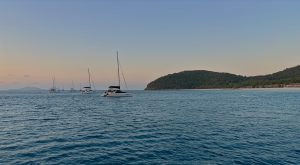
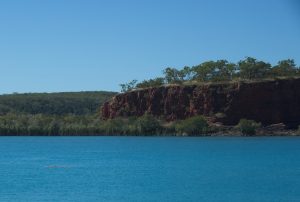
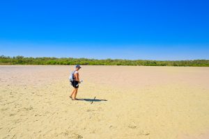
The first leg of this stage will require an overnight sail to Thomas Bay. To this end we departed Broome around 1400 hours^ on Thursday 6th June, with good winds and current in our favour, we arrived at our destination almost twenty-four hours later. With Cape Leveque and Leveque Islet at its northern end, the wide shallow bay with a large section of stunning ‘iron ore’ ochre cliffs, and a gorgeous beach provided an excellent rest stop. (^NB Leaving later in the day allows us to arrive at unknown destinations in daylight hours so we can spot any uncharted obstacles and anchor in daylight hours).

Next day, at 2100 hours, we upped anchor at Thomas Bay hours bound for The Kimberley. There was little wind, so engines were on, but we did have the tide in our favour which helped us along. Tides and current will become extremely important and together with wind direction and strength will need to be factored into our sailing and stoppage plans as we move throughout this region.

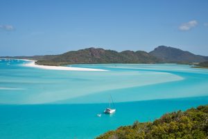
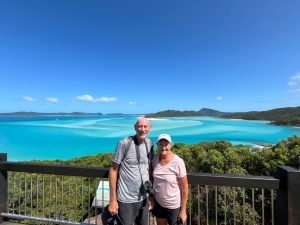
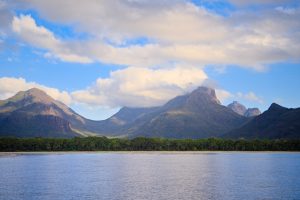
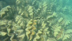
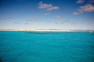
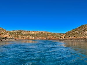
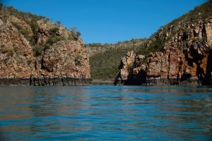
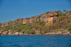
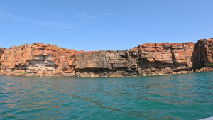
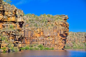
Peter had the 0400-0700 shift; and when Sandra woke up to take over it was to the startling reality that we were in The Kimberley. Bucket List #2 achieved . As we entered Goose Channel, it was Alice in Wonderland-ish, the cliffs were stacked with chalky white boulders, like something from the Flinstone’s. Then we were passing the famous Silica Beach. (We didn’t stop here as we have visited such beaches in Queensland). As we continued to motor along, the cliff appearance changed to what we would usually associate with this region – tall sheer red sandstone with the low tidal mark clearly visible. Vegetated islands and rocky outcrops dotted everywhere, and the sea was bubbling away like a cauldron. At times, wind against tide and opposing current caused Sea Goddess to move forward side on, at about a 45° angle to our heading, which was disconcerting and it took a while to adjust.

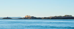
We passed small islets called The Piccaninnies; Galah Channel running between Cockatoo and Irvine Islands, then Parakeet Channel between the north end of Cockatoo and Koolan Islands. (Koolan Island is huge and is currently mined for iron ore).

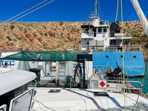
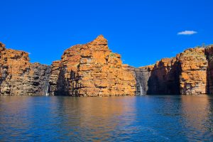
Next was a stop at a 24 hour fuel barge which sits in the middle of a bay. ULP and diesel $4.00 per litre (We’ll never complain about fuel prices again!). While we were there a tanker docked on the starboard side of the barge to refuel the fuel dock! We got chatting to the operator who told us he does two weeks on the barge and two weeks off. He is based in Broome and flies in and out from an airstrip on Cockatoo Island, then via power boat to the barge. Sitting alongside the power boat was a much larger motorboat where barge operators live while they are here. He also had Drumstick ice creams for sale which we couldn’t resist and treated ourselves. After refuelling we made our way to our overnight anchorage at Silver Gull Creek. A gorgeous spot surrounded by a horseshoe of majestic cliffs and sparkling crystal-clear water. As we take it all in, both of us are in awe, feels surreal that we are finally here. Photos below of the Dog Leg Creek Fuel Barge, Sea Goddess in the foreground and the refuelling tanker in the background.

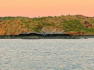
As we prepare to depart for Silver Gull Creek it’s sunrise, a magical time of the day and the effect of sun rays on surrounding cliff face is stunning. The escarpment is ever changing due to weathering, and with low tide the rock outcrops in the water look as though they are sitting on plinths (like a statue). There is no doubt we’re going to run out of superlatives to describe the magnificence of what we are seeing and experiencing here, and its only Day 2.

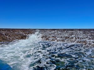
Traversing ‘The Canal’ between Koolan Island to the west, and the mainland to the east, it wasn’t possible to sail due to the current flow, so we motored. Through our journey in this region, there are times when the current is so intense that our boat literally skates or slides on top of the water, you have no control without assistance from the boat engines. So whoever is at the helm must be ever vigilant for these eddies and/or areas that look like a circular mirror obscuring the current underneath.

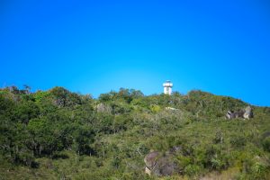
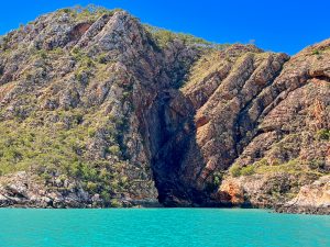
We had the option of going through a gap between Koolan Island and Round Island called ‘The Drain’, even though we only draw 1.25 metres we erred on the side of caution and deemed it too shallow at low tide so we opted for ‘The Gutter’ between Round Island and the mainland. With both engines on we moved through the bubbling water with no problems. This took us into what is known as ‘The Channel’, to the west is the top end of Koolan Island to the east is a craggy group of islands called the Iron Islands. At the end of Koolan Island is a yacht club, Yip sitting high upon the hill. Who would have thought. Honestly, it looks totally out of place up there, and we’re baffled as to where they would get their membership from. The photo below shows ‘The Gutter’.

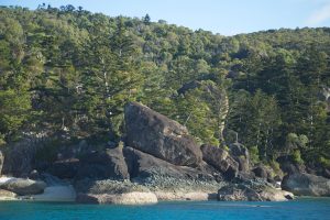
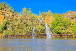
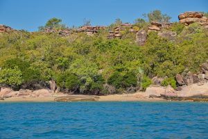
We continued on, passing a series of islands and islets with contrasting vegetation. Some densely vegetated (like tropical north Queensland or Hawaii), whilst others are basically barren rock with a scattering of spindly pink hued trees here and there. We reached the head of Dugong Bay by late morning and motored across the bay to check out Dugong Falls, unfortunately there was no water flowing. C’est la vie!

Talbot Bay & Horizontal Falls

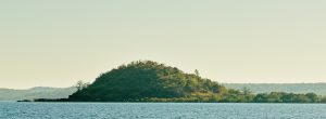
We left Dugong Bay the next morning at low tide, tidal markings clearly visible on the cliffs with the underbelly on show demonstrates the significant tidal range in this region. Large mangroves were fully exposed; mud flats reached out from the bottom of craggy structures and cliffs, and rocks which were submerged at high tide were now on full display. As we made our way to Talbot Bay there were lots of small, vegetated islets and striated rock formations dotted along our route. After 4 ½ hours we reached the channel to Talbot Bay, passing Slug Island on our way to the anchorage point. When we got a close-up lateral view of the island it really did look like a slug.

Western Australia

As we exited the channel and entered the bay, we noted two cruise ships anchored – Coral Geographer and Scenic Eclipse II. Just by looking at Scenic Eclipse II you could tell it was high end, beautifully maintained with helicopter and helipad atop and towards the stern. A covered staffed platform at water level was in place to assist passengers to embark and disembark from zodiacs which were operated by crew. Once anchored we took our tender along the cliff line to check the bay entrance to Horizontal Falls. Pegged it right, so we went in as far as the narrow gap between the two rocks faces – this is where all the fun happens. Rapids bubbling away, tide still coming in. Peter suggested we wait until this afternoon for slack tide before we get the engines cranked and cross the gap. (Two tenders, fully loaded with passengers from Scenic Eclipse II were also there checking conditions and opted not go through at this time).

We then headed back out to the bay and continued southeast to cruise along the cliff line taking in the majestic surrounds of the bay. Then turned back to the Horizontal Falls Sea Plane Charters pontoon with hotel style accommodation which sits in the water towards the far end of the bay. Several high-powered ribs docked here (these are the ones that you see on the tourist TV shows and can traverse the Falls at super high speed).

Shortly after we arrived back at the boat we were visited by five WA Parks and Wildlife officers in a small power boat. A female and a male officer came forward to the bow and led the conversation; two remained in the small cabin just observing and one was at the side on a handheld electronic device. Conversation was low key, just the usual questions and getting a feel for who we were and our travel plans. Peter showed them the purchased Dambimangari Aboriginal Corporation visitors pass ($55.00 for one month), which allows access to specific areas of Dambimangari country, including Horizontal Falls. They were surprised that we had it! They chatted to us about being croc aware and not leaving the tender in the water. Told us stories about other boaties using gaffe tape to cover up bite marks, so the stories of rubber dinghies like ours being used as ‘teething rings’ are true! We raise our tender after each use, so the risk is minimal, and just in case we do have gaffe tape on board. They gave us a bag with a number of pamphlets about the region before they left.

Mid afternoon with the tide in our favour we kitted up in our Kimberley Coast Sailing Yacht Club* gear and took the dinghy through the first gap in the cliffs i.e. from Talbot Bay. The second gap is much narrower and where it all happens, Peter checked that I was ready, revved the dinghy engine and with the water madly bubbling and swirling we went through the gap. The dinghy was buffeted from side to side, and swung nose to stern a couple of times, it was exhilarating. (We were so glad we had a good sized engine. Anything less powerful and we would have had difficulty controlling the passage). Once through the gap there are large pools of swirling water, and beyond this is a third gap called ‘The Narrows’. Not only was the gap between cliffs really narrow, the water was speedily swirling (even more so than the one we had just came through) there was also clearly discernible drop in the actual water level at the back end. We didn’t feel comfortable going through or exiting this one, so we turned around and headed back through the second gap again. Much more fun the second time as you knew what to expect and it was easier to fully engage and get that adrenaline rush. Sandra caught all the action on GoPro so it will be great to have our achievement captured to show family and friends, as well as for us in the future.

Sailing Australia

The Kimberley

Back to the boat, we celebrated with a glass of wine while we waved to a few zodiacs from Scenic Eclipse II who were headed to the falls for their dose of excitement. The helicopter had been doing a roaring trade all day. As well as sea planes buzzing in and out as well. Both cruise ships left later that day, while we rested up for our onward passage the next day. Peter also organised an Uunguu Visitor Pass which allows us to access several significant sites within The Kimberley, from Careening Bay upwards. Cost of the pass is $100.00 per person and can be purchased from their website http://www.wunambalgambera.org.au

At 0600 hours we upped anchor at Talbot Bay. We’ve noticed that the more north we go the murkier the sea water, probably due to a number of factors including that the water temperature is much higher which promotes a lot more nutrient and growth in the water; the seabed is mud as opposed to sand; the current and tides stir things up as well. So, when we retrieved the anchor and anchor chain both were smothered in gooey mud. Luckily, we have a sea water wash outlet onboard and a dedicated sea water hose, and we used this to wash it off as we retrieved the chain and anchor. Added about 15 – 20 minutes to the process, but is worth it given the reports that any residue mud smells and we want to avoid that in the anchor chain locker.

Motoring along, and once out of the channel, we moved offshore passing lots of islands, islets and rocks. Some of the latter are partially above sea level all the time, others are only visible at low tide. Peter does an amazing job of accounting for these, plus a myriad of other factors including water depth; current; tidal movement; predicted wind direction and force when he is planning our routes.

Melomys Island

After 6 ½ hours we arrived at Melomys Island for an overnight stop. We had just anchored when a large saltwater crocodile just visible above the water line slowly swam passed, about 100 metres from the stern of the boat. (Croc sighting #1). Didn’t come any closer but was clearly checking us out. As an aside, prior to leaving Horizontal Falls we read an information pamphlet on fresh water and saltwater crocodiles and in particular safety measures when moving via sea or land throughout the top end of Australia. The pamphlet was included as part of the package that Parks and Wildlife Officers had given to us. Next morning we followed the island coastline as we made our way to our course for the day. Looking back, we spotted a crocodile, Sandra saw it first, mostly out of the water on a sandbank and it was huge, when I got Peter’s attention it was back in the water. Not sure if it’s the same one we saw yesterday but we’ll log it as Croc sighting #2. Look closely and you can just see it to the left in the water.

Melomys Island

Montgomery Reef

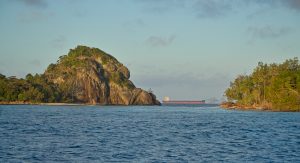
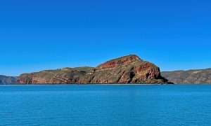
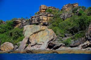
Our next destination was Raft Point, arriving midafternoon, the small cruise ship National Geographic Orion was anchored at the entrance to the bay. Lots of zodiacs taking passengers to the mangrove areas, which almost encapsulated the bay, and out to rocky islands to the west of the bay. Just as we were about to anchor, Sandra who was up front noticed a crocodile lurking near the mangroves on the south side of the bay, luckily the rubber zodiacs weren’t close, and neither were we thank goodness (Croc sighting #3). Peter wanted to anchor away from the mangroves and the cliffs, basically in the centre of the bay, but this area created difficulties and the anchor wouldn’t set due to the undulating seabed. So, we moved around the corner to Doubtful Bay – sheltered, peaceful and surrounded by majestic cliffs, just perfect! Photo below: passing amazing scenery as we make our way to Doubtful Bay.

Western Australia

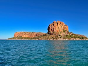
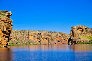
We were up as the sun’s morning glow appeared over the mainland, and made our way to Montgomery Islands, and particularly Montogomery Reef. We passed Steep Island, a massive sandstone structure, shaped like an uncut loaf of bread with rounded top. The sides were steep, deeply sliced (indented) and dropped vertically into the sea. Whilst a craggy outcrop with no name sat nearby. As we motored along, a passenger power cat named Reef Prince was behind us and gaining quickly, so as a courtesy Peter contacted the bridge via radio to clarify their intentions. Their plan was to head across our bow and anchor behind Kimberley Quest, another small passenger cruise ship anchored ahead. So, we slowed up to allow them to pass, eventually pulling up a short distance from their port hull. As we were prepping for our excursion to the reef, we were contacted via radio by a senior member of Reef Prince inviting us to join passengers and a guide on a two-hour reef tour (at no cost). Absolutely! Ten minutes later we were in a rib with five cruise passengers and Jackson, our guide and driver. Paul was in another rib with about twelve passengers, and Ruby had about eight in her rib. Photo of Steep Island below.

The Kimberley

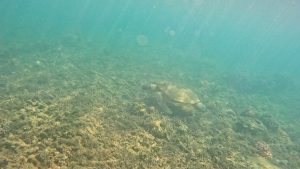
The tour was fabulous. Initially we made our way to Turtle Gully and yes we saw quite a few turtles as well as a small shark. Into the main channel where there were larger flows of sea water cascading over the terraces of coral. (It was a Neap tide, so as Jackson explained not as full on as during Spring tide, but we were able to get up much closer to the terraces and the action which wouldn’t occur in Springs). Further along we spotted Eastern Great Egrets; a couple of Grey Herons; more turtles; a super long cream coloured sea snake, and a huge blue stingray. After exiting the channel, we then returned to Sea Goddess. Next stop for an overnight stay and visits to two waterfalls was Red Cone Creek. Photos below: Coral terraces and ‘Sir Hiss’ the snake.

Red Cone Creek

We passed Raft Point, Steep Island and Doubtful Bay along the way. And wow this isn’t a creek it’s more like a huge river lined on either side by thick mangroves. The main lagoon section, broke off into two tributaries at the far end, likened to a ‘Y’ and even these were very wide. We anchored in the lagoon as the setting sun turned azure blue to yellow, orange and finally red hues; then the sky lit up with the most amazing display of stars.

Next day we whiled away the morning waiting for the tide to rise enough to take the dinghy to see the two waterfalls. Taking the left tributary you will reach Sapphire Falls, to the right Ruby Falls. Once the tide was right and with all our bits and pieces in the dinghy we headed off, firstly taking the tributary to the right for Ruby Falls. (Usually, we both sit on the outside tube of the dinghy but being croc safe, Sandra sat on the internal plastic seat while Peter brought along our large esky to use as a seat).

We coasted along keeping to the middle of the channel, avoiding the banks and shallows. Gradually the mangrove lined channel narrowed. Coming around a bend and there near the bank, with just the top of its head above water, was a croc (Croc sighting #4), we zipped passed it and continued. Further on we took a fairly sharp left turn into an even narrower channel with a mangrove growing in the water, plus a large fallen log. Together they were blocking half the channel which would require us to go closer to the bank. Sandra was scanning the bank when suddenly Peter depowered the dinghy and started to turn us around. Initially Sandra was confused, then Peter pointed to a large partially submerged crocodile i.e. we were so close we see the ridges on its back, and it was totally blocking the other half of the channel (Sighting #5). Peter got us out of there quick smart, and we headed straight back to the boat.

The plan to go to Sapphire Falls (taking the left tributary) was abandoned. A photo of a waterfall, that may or may not have water flowing, was not worth putting ourselves at risk of a possible croc attack. (Addendum: In hindsight we regret not trading in our current tender/dinghy for a metal one, which all the cruise ships use. We had discussed it when we were in Adelaide prepping for this trip but decided against it at that time. We would certainly recommend this to anyone considering a sailing trip to this part of the world).

Deception Bay

Up at 0430 for an 0500 start to Deception Bay. Thus far we have experienced relatively calm – slight sea conditions with wind force on the low side and the direction has been fickle. The current can also be advantageous while it’s with you, until it’s not. As a result, since leaving Broome, we have generally motor sailed with the headsail and/or mainsail out to catch whatever breeze we can. Even an extra half a knot can make a difference over a 10-hour sail. A massive difference from the turbulent conditions further south, thank goodness.

As we moved along, on the mainland tall craggy cliffs made way for softer, rolling hills. Via binoculars, Peter spotted a crocodile sunning itself on a beach near Freshwater Bay. A big one too, about 5 metres in length (Croc sighting #6). So many beautiful pristine beaches along the coastline, all deserted. Clearly, the ‘Be Croc Safe’ message is getting out – it’s not worth the risk. And even if you can’t see them, it doesn’t mean they are not there, patiently watching and waiting.

Purely a rest stop, we had a pleasant overnight stay at Deception Bay before moving on the next morning.

Sheep Island

Heading for another overnight stop at Sheep Island. Stunning scenery particularly at the south entrance to Camden Harbour on the mainland to starboard, Kannamatju Island to port. We passed Kuri Bay … where an active pearl farming operation was in place. While we were chugging along, a sea plane flew over, landed in the bay and made its way to a dock located close to buildings on the shore. We wondered if it was bringing in a customer or two.

As we moved on, we could see the McDonald Ranges in the distance, with a mesa Imorogu Tabletop and Mount Lookover both dominating at this point. We anchored in Brecknock Harbour on the southwest side of Sheep Island early afternoon.

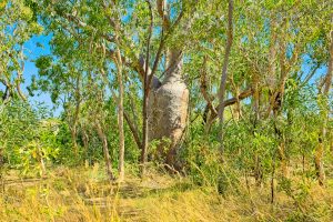
No sheep here in fact it is uninhabited, though once upon a time it was a farming community. Sandra became emotional when reading the history of the island. In particular, the story of Mary Pascoe who died here during childbirth in June 1865. (Conditions on the island would have been incredibly harsh at the best of times, and with no access to midwifery or medical expertise and support, childbirth complications would have been horrific for many). If reports are correct, her baby daughter died two months later. So incredibly sad. From our internet search we established that her grave, sitting alongside a boab tree, is well marked with a head stone though the inscription has weathered beyond recognition. The graves of others who died on the island are also there, but not at the same site. We had intended to visit the island and Mary’s grave; but unfortunately, not long after our arrival the wind picked up and choppy sea conditions negated a dinghy ride to the island. But as we motored passed the island and the boab tree the next morning, our thoughts were with Mary and her daughter. Sorry about the quality of the photo, its the best one we could get as we passed in the early morning sunrise. The outline of the boab tree in the foreground to the right of the photo below is the one referred to above.

Western Australia

As we continued towards our destination, the Prince Regent River, rolling hills made way for heavily vegetated islands, islands with mesas, and/or craggy outcrops. Then onto Roger’s Strait between the mainland to starboard and a huge island called Augustus Island to port, surrounded by several smaller islands and islets. Large pearl farming operations on both sides of the Strait with lots of activity underway.

We crossed Hanover Bay to Unwins Island, lots of large exposed rocks within the Indian Ocean with at least a dozen or so close to shore, some perfectly round on top, like a bread roll, others craggy with vertical striations. Motored between Unwins and Mictyis Island. Rows and rows of horizontal and vertical ‘stone’ piled upon each other, some sitting quite precariously atop. They appeared ‘higgilty pigglty’, a jumbled mish mash of rocks that were somehow still able to create a wall or tower. Between the mainland and Unwins Island we were skating quite a bit due to the current and the presence of eddies scattered across the channel. ‘Whirlpool Point’ took this to a whole new level, lots of agitated water and swirling pools that Peter navigated with great care and precision. We continued to head down the channel towards our anchorage point, passing the eastern aspect of Midway Island. After some difficulty anchoring due to depth and an undulating seabed, we switched to the other side of the channel and anchored just southwest of Greville Island.

Our anchorage point was at the very top of the most northeast section of the Dambimangari Indigenous Protected Area (IPL) and the most northwest section of Prince Regent National Park. These two regions border each other until they reach their most southern corner, where the IPL land boundary turns and continues west, and the national park boundary turns and continues east.

Prince Regent River

The next morning, we upped anchor heading towards Prince Regent River and the Kings Cascade Falls and Cathedral Falls. Passing Marigui Promontory, then Saint Patrick Island followed by the larger Saint Andrew Island, both of which are heavily vegetated. (In our view, St Patrick Island may be smaller, but the topography is far more interesting and prettier). Between the islands, and in the distance a huge mesa sits atop a large hill on the mainland. From here we entered Saint George Basin, a huge body of water encircled by the mainland and split by the river. Peter spotted a croc in the middle of the Basin, heading across from St Andrew Island to the mainland (Croc sighting #7).

By 0830 with the current in our favour, thanks to Peter’s planning, we were making good time. And by 0850 we had reached the entrance to Prince Regent River where initially mangroves lined both banks. Then things started to get interesting, with heavily vegetated hills and cliffs to port whilst those to starboard were less so, scraggy trees and bushes on this side but the huge outcrops of naked rock were stunning. Another croc sighting in the river to starboard, eyes and back just visible above the water line (Croc sighting #8).

During our river passage this morning, a small old style power boat named Andante was in front of us. With the movement of the boat, sometimes on one side, sometimes the other, sometimes in the middle, Peter quickly caught on that the skipper knew the river well particularly from a depth perspective, so we followed. They were moving much faster than us, so we lost sight of them for a while. When we met up with them again, they had anchored. We had a quick chat over the side of each boat and Peter indicated we would anchor further on closer to the falls. But, after a short discussion between the two of us we didn’t venture much further before turning around to anchor behind them. Local knowledge is everything up here. So, we sat having dinner in the middle of the river watching the tide drop lower and lower until there was more mud flat than river in the channel. No crocs so that was a good thing.

Western Australia

Peter was up during the night as the anchor ball (which together with the anchor light alerts other boaties that we are anchored) was banging around and about 4-5 large birds were trying to perch at the very top of the mast and spreaders. They were making a huge raucous, and did not like Peter disturbing them, but they eventually got the message. (We saw them the next morning and were able to identify them as eastern osprey).

Today is all about the falls. Moving easily along the river in the dinghy, we reached King Cascade Falls which were flowing and made a stunning picturesque scene. If you can imagine a tall, rock entrance at the opening to the river, which then made way for a horseshoe wall of rock about ¾ of the way around on either side then into mangroves. The falls flowed both centrally and slightly centre left. We had been following a small power boat to the falls, and as we arrived the guy called out that they had spotted a 3-metre crocodile in the mangroves on the left bank. We took the dinghy into the middle of the pool in front of the falls, we didn’t see the crocodile, but erring on the side of caution we took our photos and headed out.

Western Australia

As we were leaving the tinnie from Andante arrived, they were planning to climb through the scrub to the top of the rock wall i.e. above the falls. We gave them a heads up re the crocodile, then left and made way further along the river to Cathedral Falls. Part way along our route Peter noted two huge splashes from the riverbank, one immediately after the other, too big to be fish or birds. Looking into the murky water. we couldn’t see anything, but Sandra was spooked. To reach the falls requires moving through a narrow creek, we were the only boat headed to that location at this time, all the other tenders in the river were metal, and given our croc experience at Red Cone Creek we decided to give this set of falls a miss.

We were so glad to spot Sea Goddess in the distance, and once back on board, we upped anchor and followed our track back to the river entrance. We made excellent time with the assistance of the current behind us, entering Saint George Basin around 1330. Then through the channel, returning to our previous anchorage spot for the night.

Next morning we were heading between the mainland and Greville Island. With a 3.6 knot current directly in front we were skating a bit, lots of turbulence and eddies particularly so through Whirlpool Point. Fish, large and small, jumping out of the water, birds circling overhead and diving down hoping to grab one for breakfast. Moving northward we were buzzed by low flying plane, and 45 minutes later we received a radio call from Border Force asking where we had come from and where we were heading, and our ETA for arrival in Darwin. No questions about who was onboard or any other details were required. Whenever we are underway, we always have AIS operational. (The automatic identification system, or AIS, transmits a ship’s position so that other ships are aware of its position, in order to avoid collisions. But it can be used by a myriad of authorities for other purposes).

By early afternoon we were motor sailing passed Cape Brewster, truly magnificent rock formations on the mainland; whilst to port there were a collection of low-lying islands one after the other – Glavert; Grey; Coronation; Gale; Mably; Fontanes Islands; Desaix Islands; Wickam, and Museums Island. We made way between the mainland and Glavert Island, anchoring in the gorgeous waters of Careening Bay around midafternoon.

Careening Bay*

Around 1945 we had just finished dinner when a large power boat arrived. It’s pitch-black outside and the boat is lit up like a Christmas tree, and by default so are we. Two tenders get loaded up with people who then proceed to the beach. With binoculars on we could see the handheld torches moving this way and that as they explored the scrub for about 20 minutes. Then back to the power boat, left about 45 minutes after their arrival and the last we saw of them they were motoring westward. Totally odd. We then spent the next half hour or so coming up with crazier and crazier scenarios of who they were and what they were doing. You have to get your entertainment somehow!

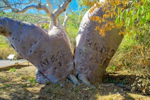
Up a bit later today at 0700, waiting for the tide to turn in our favour before moving on around 1100. In the meantime, Peter over to the beach on the mainland to a very special boab tree, ‘The Mermaid Tree’. The tree was inscribed by a carpenter on Phillip Parker King’s survey expedition in 1820. The expedition was tasked with accurately charting the Kimberley coast on the HMC Mermaid and HMC Bathurst. The tree has survived all that time, as has the inscription. It is National Heritage listed, but currently is not in good condition. So, we are really fortunate to have had this opportunity.

We got underway as scheduled, and five hours later we anchored for an overnight stop between the WA mainland and Tjungkurakutangari Island. (Don’t ask us how to pronounce that). Outcrops of lava like craggy structures randomly sitting in the sea just off the island shoreline; like something from the Star Wars or Mad Max movies. Rolling hills on the mainland moving round in an arc to large red ochre cliffs. As you can imaging sunsets here are spectacular.

Bigge Island

Our next overnight stop was Wary Bay, Bigge Island*. This is a huge drawcard for cruise ships and cruisers due to its famous indigenous rock art which is located in rock caves easily accessible from the beach. When we arrived the cruise ship Coral Geographer was already anchored, and as we drifted, we watched with interest as a series of tenders took passengers over to the island and escorted them up the beach. Which gives us a heads up on where we should land the dinghy tomorrow and we can also follow their tracks.

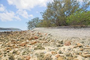
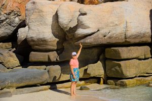
Heading into anchorage after the cruise ship left, we made our way closer to shore when Peter noticed a significant and sudden drop in depth. We carefully backed out and moved to anchor further offshore. Just as well we did, because at low tide that area became an above sea level reef. And we would have been sat atop it! Photo below shows the tidal range, here it’s low tide.

The bay itself is beautiful, surrounded on each side by magnificent stone cliffs. And we were treated once again to a spectacular sunset. But Mother Nature just keeps giving, around 1830 we saw the beginning of a soft creamy-pale yellow glow from the rising moon behind the island, and then the waxed moon itself rising quite briskly into the night sky, add in the super clear milky way and sparkling stars and it was just magical.

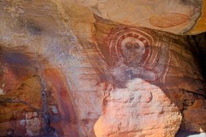
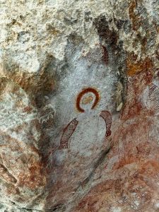
Fabulous start to the morning. As we took the dinghy to the beach we saw two large turtles, one heading out to sea and the other close to the rocky cliffs just after landing. Making our way towards the onshore rock caves, we discovered that the area is a turtle breeding site with three large, albeit empty, nests located quite closely together. Walking passed these, being careful not disturb anything we easily found the rock caves. There are three in total and initially we couldn’t locate any of the indigenous rock art that the caves are famous for. But we kept looking; then in the last cave we spotted our first painting, then another and another. At times we had to move quite deeply into each cave, squeezing through narrow passages or hunkering down to locate them. But when you found one or at times a cluster of paintings it was like finding gold. Just amazing. Unfortunately, some are now lost or obscured due to weathering, particularly those closest to the sea and/or cave entrances. But what we saw was super special. Equally special was an encounter with a white bellied sea eagle who flew very close to us, and at eye level, as we were standing near the water’s edge.

The Kimberley

Wollaston Island

Indigenous rock art abounds throughout The Kimberley region, and we made way to another well-known location on the mainland near Wollaston Island*. Six hours later we were anchored between the island and the mainland.

We left Sea Goddess around 0900 the next morning and took the dinghy to the beach on the mainland (directly opposite our anchorage). The beach was surrounded on both sides by humungous rocks which encapsulated the small beach. Someone had created a shell collection on top of one of the rocks including two conch shells, and we wondered if this was a directional point or just a collection of shells. Lots of footprints leading to rocks, but there was no discernible pathway.

Peter went off to explore and found two caves at the top of the island, returning to let Sandra know he had found one site* (there are apparently several rock art sites in this area). We both climbed up the rocks then along a narrow track between two massive vertical rocks before reaching the top of the island where it flattened out to typical Aussie scrub (scraggy trees and bushes; tall grass; spinifex) … and a path that led to a large cave. Gorgeous rock paintings were located on sides of rocks, underneath rocks, on top of rocks, several were metres above ground level. Like Bigge Island, some were in better shape than others, and many were weathered but stunning, nonetheless. Underneath a massive rock was a circular space surrounded by smaller rocks which had the look and feel of a special place. So, we stayed on the edge not wanting to disturb anything and just let the atmosphere settle over us before returning to the dinghy and Sea Goddess.

Western Australia

Not long after our return we upped anchor and headed to another renowned rock painting site, Swift Bay, anchoring there by late afternoon.

Swift Bay

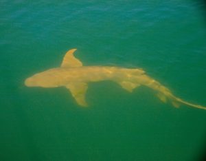
Next morning our anchorage neighbours stopped by in their dinghy and gave us some information and directions as to the best places to view the paintings. Based in Darwin they are regular visitors to this region. While we were chatting a large tawny nurse shark arrived, circled our boat and their dinghy. They told us that the shark is a regular visitor, mooching for food.

Shark

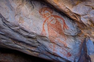
Around 1200, and with a good idea of where we were headed, we took the dinghy to the southern end of the bay. It was just off high tide, so some rock areas were exposed. We got the dinghy in as far as we could, Peter tying a line to a rock. Then we picked our way up, using the rocks as steps till we came to a gravel path in front of a massive rock. We were following the path in front of the rock, when Peter noticed the first rock painting, just beautiful.

The Kimberley

The path wound its way through long grass and more rocks, to another massive sandstone rock where more paintings were discernible, though there were a number that had weathered beyond recognition. Some were painted on rocks very close to the ground, and the person who painted these must have done so lying on his/her back. We had done our homework and knew that these areas are common burial sites, so we were careful not to move or displace anything. We took lots of photos before making our way back to the dinghy.

Once aboard Peter followed the coastline to another large section of rocks which hugged the water’s edge. There are known rock paintings here as well, and though we didn’t see any we used the GoPro to film the rocks* and there might be more to see here when we download the footage. Then it was a dinghy ride back to Sea Goddess for lunch and prepping for our overnight sail.

Vansittart Bay

First overnight sail in a while, heading to Vansittart Bay to see the DC3 (USAAC C-53), aircraft wreckage*. The wreckage has an interesting history as follows. In February 1942, during a flight from Perth to Broome to assist with the evacuation of Dutch citizens from Java, the pilot of the DC3 became disorientated. The plane veered off course and was forced to land on a saltpan on the Western Australian mainland near Vansittart Bay. All four crew members survived and were evacuated by sea plane.

We anchored in the bay around 1015, Peter had checked the wreck coordinates from the Uunguu Visitors Guide, so we had a good idea where to beach the dinghy. The visitor guide also directed us to a piece of pipe lodged on top of a sand dune, which was easily identifiable as we neared the beach. Once landed we checked the sand for any croc trails, then walked up the beach to a small sand dune via a well-used path (footprints everywhere). We passed the ‘pipe’ at the top then made our way down the other side to a saltwater lake that is walkable at low tide.

We were a bit nervous as we walked on the path to the lake, as it required us to walk through mangroves (a known croc hideout). Peter was carrying an oar from the dinghy, our only ‘weapon’, and keeping a close watch on either side of the path we got through okay. The visitor’s guide had also alerted us to the possibility of feral cattle on the lake that have been known to become aggressive and ‘charge’ at times. At this stage Sandra’s thinking, Jeez I hope this is worth it! Walking across the lake we could see the imprint of boots, sneakers and hooves!! As well as what looked like emu or crocodile prints (really hoping it’s emus). The closer we got to the middle of the lake the gooier it became which impeded our plan to walk briskly.

Once we reached the other side of the lake there were no markers or signage, just more mangroves and scrubby bushes and trees, discernible footprints went every which way. We took a gamble that the plane would be roughly in line with the pole on the other side of the lake. The first gap in the mangroves and scraggy bushes led nowhere, the next one we looked down Peter could see the plane a short distance away and we made a beeline for it.

For its age the plane itself is in remarkedly good condition. The middle section of the fuselage had been removed which opened up the front and back sections of the plane. This allowed us to carefully step along narrow steel beams to the cockpit and the inner tail section (there was no floor or ceiling in place). One engine was still on site, as well as both wings and landing gear. As an added bonus we spotted a large, healthy boab tree nearby.

Vanisittart Bay

The plane was well worth the visit, and the journey to get here was something we will remember and talk about for a very long time. We made the return trip to the dinghy with no issues. After lunch aboard Sea Goddess, we departed Vansittart Bay for another overnight sail to Glycomis Bay. At 0300 hours we passed the most northern point of Western Australia.  Big tick for achieving this milestone, Yeah!

Glycomis Bay

We anchored around 7-ish in the most stunning bay, once again lined with rock structures that rise out of the water’s edge and create a wall of patterns and colours. Reds, oranges, creams, browns, greys and black. Some with vegetation emerging from cracks. In other areas the rock structures are interspersed with trees and mangroves. It sounds random, and in one sense it is, but put it all together it creates the most amazing natural setting.

That afternoon we took the dinghy around the corner from our anchorage point to a narrow U shaped bay to see Glycomis Falls. This smaller bay is equally stunning with the surrounding cliff face reminding us of Indiana Jones movies. Unfortunately for us there was no water flowing, well there was a trickle. But you could certainly see from the discolouration of the rock where the falls would flow, and it would no doubt be a fantastic sight to see.

Exiting the falls area we headed back out into the main bay following the east – northeast coastline to the Lost City (photo below).

Amazing rock formations all along this strip with huge slabs of fallen rock at the water’s edge. Once upon a time people lived here. We didn’t walk up the hills to the ‘City’ as this would have required us to walk through dense mangroves and we were concerned about the possibility of crocs. So, we retraced our track back along the water’s edge to Sea Goddess. Then it was time to get prepped for an early sail tomorrow and our last few days in The Kimberley region.

*Each person will need to purchase a Uunguu Visitor Pass to access these islands/sites (currently $100.00pp). The Visitor Guide, available on the website, provides an overview of each major tourist attraction, directions and restrictions if applicable.

King George River & King George Falls

At 0430 we upped anchor at Glycomis Bay to ensure we reached King George River with the correct tide. We also had the benefit of a 1 knot current behind us, so we made good time arriving at Koolama Bay around 0730. We anchored for a short time while we waited for the depth of the river entrance to accommodate Sea Goddess’s draft (undercarriage) requirements plus some wriggle room. For the first time we would traverse a river up close and personal aboard Sea Goddess rather than the dinghy which made this excursion that much more special. We entered the river entrance at 0900, and just WOW-WOW-WOW we were immediately overwhelmed by the amazing scenery surrounding us on both sides. In his planning Peter had certainly saved the best till last.

The Kimberley

As we got closer to the falls the river narrowed to form a canyon with stunning cliffs towering over us on either side. Lots of ribs from a cruise ship passing by as they too headed for the falls.

The KImberley

Once reached there are two falls, one on either side of a huge dividing wall of rock. Not a lot of water flowing, but enough to be impressed and get some great photos.

The Kimberley

With a feel for the river’s turns and topography, we made our way back to the river entrance at a slow and steady pace which allowed us to soak in the majestic surroundings. It would also be our last day in The Kimberley region, so we wanted to make the most of these last few daylight hours and bank them in our memory. No doubt we will benefit from the large number of photos and video clips we have taken and stored over our time here.

We exited the river at 1220 and by 1300 we were anchored in Kooloma Bay in front of Lesueur Island for an overnight stay. To anyone reading this blog, we would highly recommend a trip to this part of Australia which is full to the brim with the most amazing scenery and experiences. Throughout our time in the region the weather has been glorious with lots of sunshine and cooler evenings and nights. There are several cruise ships which offer Darwin to Broome or Broome to Darwin trips. From three star to five star, they visit a number of the places we enjoyed, and no doubt other places that we missed. So do yourself a favour, grab a lottery ticket and if you win put a visit here high on your ‘Treat Myself’ list.

Darwin

At 0500 the next morning, Sunday 30th June, just as the glow of the sun started to appear over the horizon, we upped anchor at Koolama Bay bound for Darwin. Initially we headed across Joseph Bonaparte Gulf. Fickle winds kept us on our toes simultaneously managing a number of things with care – the wind changing direction and dropping in strength; sails; sea state; tides, current and fuel. It’s all part of the sailing journey. In the main, we have been very fortunate since leaving Broome not to have experienced the stormy conditions of the Southern Ocean and parts of the Indian Ocean. If anything, there has been little wind and seas have been relatively calm which has led to us relying on the engines a lot more and using more fuel than anticipated as we travel to our destinations. As a fuel saving measure we try as much as possible to alternate engines, and power up only to the required conditions.

The first night of our journey east, we were treated to bioluminescence which we haven’t seen in a while, off the rear of both port and starboard hulls. Bioluminescence is created by the production and emission of light by living organisms. As our boat glides over bioluminescence waters, the movement activates the glow of the organisms, creating a luminous path in its wake. Has a sparkle effect like small fairy lights of differing colours through the churning waters of the engines, just magical.

Early the next morning, Monday 1st July at 0610 hours we crossed the Western Australia-Northern Territory border. Not long after a pod of dolphins joined us at the bow, the first pod in a long while, a couple even breached. Obviously, a different species to others we have seen due to their colouring, snout shape and small size. As the day progressed and into the night, wind and sea conditions changed and we were a rocking and a rolling. Unpredicted changes in wind and sea state are not unexpected on a long passage such as this one. We motored through the night, Peter hand steering as our automatic steering and course navigation couldn’t cope with the conditions. Around 1145 the next day we changed course, and the wind and sea state settled a little but still choppy with a slammer every now and again.

Just before 1400 we could see Darwin on the horizon. Making our way to our anchorage we passed a mixture of watercraft including a number of cargo ships and tankers, a naval patrol boat and submarine, a port pilot boat, what we think was a huge cable laying vessel which we dubbed the Mean Green Machine due to its look and colour, as well as several small power boats and this was just in the waters surrounding Darwin. We cruised passed them all and arrived at our anchorage at Fannie Bay just before 1500 hours. Phew! We completed our post sail activities in record time then it was dinner; wine; shower, and bed.

Prior to arriving in Darwin we booked a berth at Cullen Bay Marina for a week. Accessing the marina required us to transit the Cullen Bay Lock. Peter had organised an 1100 timeslot with the Lockmaster via Channel 11 on the VHF radio. We upped anchor at Fannie Bay at 1030 making our way to the lock. When we arrived at the entrance there were two boats on the fuel-holding dock, a cat and a power boat, with another two smaller boats circling the holding bay. So, we turned around and headed back out again. After a short time, we saw the docked power boat leave so we assumed at least part of the holding dock would be free and headed back in. As we were approaching, we saw the Sealink Ferry powering down the channel, so Peter backed off to let them through first. (The ferries have a separate docking area so not an issue to let them go ahead).

Next minute two ribs come roaring passed us, one with lifeguards aboard and the other police who proceeded to pull up to the holding dock which doubles as a refuelling dock. Like the turtle and the hare, by the time we got through the entrance to the holding bay the lifeguard rib had moved on and the police rib was refuelling. Luckily there was enough room between the rib and the catamaran in front for us to dock. A lock operator came down to tell us that one of us needed to do an induction. So, Peter went with him, as one of us was required to stay with the boat at all times. Induction completed we waited.

Once we got the call up on the radio, we left the dock and slowly made out way forward between the lock walls. The lock is about 9.5 metres wide, Sea Goddess is 7.8 metres wide, so it was very squeezy. Once we got through the lock gates Sandra got the stern slip line around the uprights of a steel ladder bolted to the lock wall and held on to the free end keeping Sea Goddess in place. Peter put the bow slip line around a pole and again held on to this. As the water rose in the lock, we were required to slowly pull the line in, all the while the lockmaster with the handheld lock remote control was watching from above. Once the water was at the right depth, we made our way through the lock gates at the other end and headed to our berth.

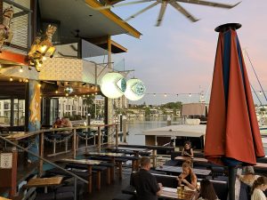
Once berthed and our post sail activities completed, we headed out for something to eat, to introduce ourselves at the marina office and have a look around our immediate environment. Marinas attract a range of eateries and businesses which overlook the berth area, and here was no different. Café, ice creamery, Greek and Indian restaurant and a quirky bar-bistro called Lolas Pergola. Quirky is good, so we stopped in for Sangria and pizza. Met the owners who were super friendly and joined us for a little while.

Darwin Bar and Restaurant

Though seriously hot and humid, we enjoyed our time in Darwin getting out and about on the ebikes; catching the bus here and there (while we were there a three month trial of free public transport for everyone was underway); chatting with other boaties including the guys from Border Force who were docked a couple of boats down from us.

Darwin Australia

Peter also spent some time working out options for the trip to Cairns, and in particular tides. Whilst factoring in our marina departure time by midday on Wednesday.

Option A: Up super early on Wednesday morning to be at lock for 0600.

Option B: Leave berth around midafternoon on Tuesday for a 3pm lock time and stay overnight at anchor in Fannie Bay. We would then leave a little later on Wednesday morning to address the tide issue.

We opted for B even though we’ve paid for the berth till Wednesday midday, Sandra wasn’t keen to go through the narrow lock in darkness/semi darkness.

We traversed the lock on time with no issues and made our way to the fuel dock. Cost of diesel $1.95/litre which was half the price of Dog Leg Creek so we were cheering. Our overnight stay at Fannie Bay was comfortable and at 0700 the next day, 10th July, we upped anchor for Cairns. Queensland here we come!

Thank you so much for taking the time to read our blog, we hope you enjoyed it. Till next time take care everyone xx

Sailing Australia

For ease of location we have grouped all the anchorages we utilised for the Broome to Darwin leg into one blog. Refer below or click this link https://seagoddessadventures.com/broome-to-darwin-anchorages/

For our review of Cullen Bay Marina please click here https://seagoddessadventures.com/cullen-bay-marina/