Duration: 25 days
This leg of the trip would be one of our shortest thus far, and we were up early to exit the marina with the advantage of high tide. We retraced our passage to Fitzroy Island, and once again the south easterly wind together with choppy seas put paid to any chance of sailing. So, with the engines on and mainsail up for stability we were travelling along the channel between the island and the mainland quite nicely when we almost got cleaned up by a speedy no name fishing trawler. Either he wasn’t going to change course, or he wasn’t on watch. Peter had to quickly take evasive action to prevent a collision, and as he did, we could see that no one was at the helm of the trawler, or the cockpit, or the foredeck. Sheesh, at times traffic out here can be just as risky as on the roads.
Leaving Fitzroy Island behind we motor sailed further south between High Island and the mainland. Then onto our mooring for the night at Russell Island, an odd-shaped island joined by a spit to a gorgeous rock structure, Catalina Rocks. There are reports of pythons on the island, so getting off – that would be a definite NO! (Photo of Russell Island below).

We departed Russell Island at the ungodly hour of 0530 the next morning south bound for Dunk Island. The only benefit of getting up at this time of the morning is the opportunity to see the glorious early morning sky still sparkling with thousands of stars and a newish moon. Just as we were leaving, Sandra saw her first ‘falling star’, speeding downwards over the island into the sea beyond. Just wow! She took the opportunity to make an extra special wish.
We continued to motor sail along the Queensland coastline with a 1.5 knot current in our favour, the SE wind and waves whilst not the best were manageable. Once again along the way we were treated to amazing scenery. Heavily vegetated mountains sloping down to meet turquoise blue sea. Islands, large and small, some on their own others perfectly grouped together. Of note was:
- Russell River with a large low bank of horizontal cloud hovering at the river entrance giving an almost supernatural appearance.
- Johnstone River entrance and Innisfail.
- The large land masses of Double Point and Lindquist Islands sitting closely off the mainland, then
- North Barnard Islands followed by South Barnard Islands and Murdering Point – we wondered how that got its name!
(When we lived in Queensland the weather presenters often mentioned Innisfail, as the township has one of the highest annual rainfalls in northern Queensland. Sandra never knew where it was, now she does ).
Just a tad over 9 ½ hours after leaving Russell Island we anchored between the famous Mission Beach and Dunk Island jetty and spent the evening planning our exploration of the island tomorrow. But before we leave this section here is an early morning piccie of low cloud, in the distance, over the entrance to Russell River.

Dunk Island
We had the perfect start to the day with a lovely sleep-in till 0800, then Peter cooked a yummy big breakfast. With both of us suitably rested and fed we took the dinghy over to the island. As we were securing the dinghy on the shore, we noticed a person on the nearby sand spit holding up a flare with orange smoke billowing through the air. Initially we couldn’t work out what was happening, then movement from above caught our eye with parachutists descending to land just 100 metres or so away. We stayed and watched as three groups made landfall, so colourful, so brave!! Leaving the group behind, and with map in hand, we headed out to complete the Island Circuit Walk …..well the ‘walk’ that turned into an eleven kilometre trek .

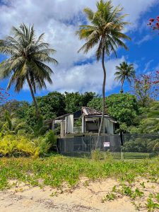
Firstly, we made our way passed the airstrip and the ruins of the resort which once upon a time was highly popular with holiday makers, honeymooners and day trippers. The resort was destroyed by Cyclone Yasi in 2011 and since this time the island has been bought by a billionaire who had plans to rebuild. Whilst a section of the resort has been restored for events, the bulk remains derelict which is such a shame. See photo below. (We understand that at this time future plans to rebuild have been abandoned). The island is accessible via private boat as well as a public ferry which provides a drop off and pick up service once each day from the boat ramp at Mission beach.
With island map in hand and leaving the resort buildings behind, we became increasingly perplexed as to the location of a path which led to the summit of Mt Kootaloo. The map said it was there but walking backwards and forwards all we could see was dense scrub. When all else fails, ask the locals. A small group were gathering oysters from nearby rocks and by the looks of things there weren’t that many left to gather. We were in luck, one of the men led us through the scrub until we could just discern the beginning of a dirt path. Up up up, we went until we reached the summit. Gorgeous island and sea views, as well as information about a WWII Radar Station previously located here. Then we descended until we reached a signed path for Coconut Beach. Not sure we got the right path, as it looked like it hadn’t been used in a while. Lots of debris and compost on the path; fallen trees and large branches across the path as well. Sandra tripped on a root or a vine and went down like a ton of bricks. Some scratches and a banged shoulder but no major damage so we carried on. At times the path petered out and we had to take a calculated guess as to where to next, lucky we chose well. Eventually the path led us to a beach with massive rocks and amazing trees, then onto Coconut Beach lined with coconut palms of course. By the time we could see the spit where the dinghy was parked our hips and knees were screaming and we were tiring. We soldiered on along the last bit of beach till we reached our dinghy, we were fortunate that it was partially in the water, so it wasn’t difficult to get her floating and the engine on. Back aboard Sea Goddess we got all the required tasks, including a stretch, completed asap so that we could sit down and enjoy some cheese, salami and wine. Ahh, bliss!! Now for an early night.
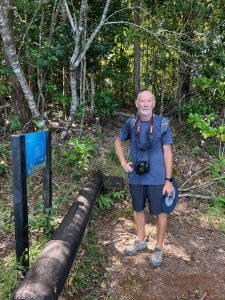
Check out our photos: Peter on the Island Circle trail; the view from the summit of Mt Kootaloo; Coconut Beach; low tide.


Hinchinbrook Island
From Dunk Island we motor sailed all day passing Thorpe, Bedarra, and Wheeler Islands – along with Dunk these are all part of what is known as the Family Island Group. Then onto larger Coombe and Goold Islands to starboard; and the Brook Island group to port.
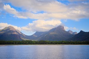
We approached Hinchinbrook Island from the seaside (as opposed to the internal channel between the mainland and the island), making our way between Cape Sandwich (for real that’s its name, possibly after the English peer Lord Sandwich?) and tiny Eva Island. Then across Ramsay Bay with its long pristine sandy beach and stunning Cardwell Mountain range in the background. Mount Bowen is the tallest peak at 1120 metres high. Just in front, and about halfway up the mountainside sat a singular peak called ‘The Thumb’, (and aptly named). Then passing Agnes Island, joined to the mainland via a rocky ledge at low tide. We were buzzed by a grey non-identifiable helicopter a couple of times in this area, we assumed by Border Force or fisheries, but unlike previous encounters we were not contacted for ID this time.
At 1430 we anchored in Zoe Bay, surrounded by lush green mountains and with a waterfall seen flowing at one end, this would have to be the most beautiful anchorage spot we have stayed in thus far. Another hidden gem.
Next day we planned to walk to Zoe Falls after lunch, just needed to wait for low tide. Timing couldn’t have been better as Sandra’s shoulder was quite sore as a result of her recent fall and both of our legs were aching, reminding us of the 19000+ steps we each did on the Dunk Island trail. So, some downtime in the morning was just the ticket. Once we could see the large expanse of sand signalling low tide, we took the dinghy over to the entrance of a large creek (where fresh water from Zoe Falls meets the bay). Once again mangroves lined the creek, so we kept watch for any movement in the mangroves or creek itself, and as we walked through a sandy-mud flat to a sign next to a camping ground. We easily found the path to Zoe Falls, a similar trail to Dunk Island. Leaf litter and roots crossing the path, and a bit rockier like an old riverbed in places. Then we had to traverse the creek which was flowing quite fast, stepping over large and small boulders as we were wearing thongs (Duh!). The path on the other side had a reasonable incline and placing your foot in some of the gaps between rocks etc was tricky at times. Then we arrived at the falls. With a large clear pool and flat round rocks at the bottom, surrounded by large and small boulders, and with trees and shrubs encasing the fall and pool area it was both serene and beautiful.

We took lots of photos then made our way along another path intending to reach the infinity pool above. Well, the path was more like a goat track, we had to hold onto tree trunks and low branches to find our footing and maintain our balance. Once we reached a set of large boulders with a knotted rope to heave yourself up to the next level, Sandra called it quits. Peter continued and had a swim in the top infinity pool. Sandra returned to the falls area to have a chat with hikers* and other visitors sharing stories from our journeys thus far. When Peter arrived back, we returned along the path to the dinghy and Sea Goddess where we immediately began prepping for our overnight sail to Townsville.
*We caught up with several hikers who were completing the Thorsborne Trail on the island. Best completed between April – September it is a four-day 32 kilometre walk through Hinchinbrook National Park and is rated one of the top ten walks on the planet. That’s impressive! It’s BYO everything, you get dropped off by ferry and four days later the ferry returns to pick you up. If you want to know more about the trail and trail guides head to the web.
With the current in our favour and seas only slight we motor sailed for the first part of the journey to Townsville, averaging 4 – 5 nm per hour. The main challenge being the erratic behaviour of fishing trawlers who were out in force on a moonless, cloudy night. By 0700 we could see Townsville in the distance, and before long Castle Hill, the port and high rise buildings were easily discernible. 0830 we were docked at Breakwater Marina.
Townsville
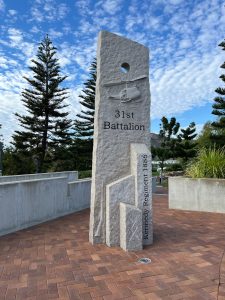
From our experience Townsville is a tale of two cities, the ‘old’ established section, close to the sea and the port; then further out the ‘newer’ housing development areas with large shopping centres and a large retail hub which includes Bunnings, Good Guys and the like. As we were located in the marina it was easy to explore the older part of town. Most mornings we walked The Strand, both a road and wide walking/cycling path that hugs the main beach. Popular with locals and tourists alike The Strand extends from the commercial port and SeaLink terminal at one end to Kissing Point at the other. It is such a pleasurable walk passing Tobruk swimming pool where the careers of a number Olympic medallists began; views over the sea to Magnetic Island; a hugely popular water park; lots of picnic tables; fountains and art works dotted along the route all covered by a canopy of established macadamia and other tropical trees. At the far end there is a seawater pool, that can be used all year round, and a track that leads upwards to Kissing Point. Sitting atop a hill with uninterrupted views around the bay to the commercial port; across to Magnetic Island and Castle Hill behind. Canons and storage buildings related to the previous military installation remain here. The history of the installation, explanatory information and memorial plaques are dotted throughout the park providing the story of the men and women who worked here.
On the other side of The Strand, restaurants, pubs, apartments, holiday accommodation and a range of eateries line the roadside and are highly popular with locals and tourists. Photos below: The Strand looking over to Magnetic Island; the hugely popular water park; Kissing Point memorial park, and a view to Castle Hill from here.


We walked to the CBD quite a few times while we were here and were surprised by the sheer lack of people. Honestly 10 o’clock in the morning and it was like a ghost town. From what we could ascertain most of the locals head to the newer shopping centres. Many of the beautiful ‘heritage’ buildings within and surrounding the CBD were empty with lease signs in place. Whilst not unlike other regional and metropolitan cities and towns, it was quite sad to see these beautiful old buildings slowly deteriorating and in disrepair. They would have been spectacular in their heyday.
Not far from The Strand sits Queens Gardens with many examples of tropical plants and trees as well as specific herb, rose and cacti gardens. The larger Botanic Gardens are a way out from town, so this is a good option when you don’t have a car. From here we walked to Cook Street to locate the share house that Peter stayed in some forty years ago. It’s still standing as are the mango trees behind, so it was really special moment for him. We also had lunch at the Seaview Hotel, his favourite watering hole back then. Photo below of Queen Gardens where some trees wear grass skirts.

We caught up with some good friends from Adelaide whilst here. They have family who permanently live and work in Townsville so it was great to reconnect once again. They have access to a car and took us to some of their favourite spots. Firstly, up through the hills to the Hervey Ranges Tea Rooms. Super old place, all corrugated iron; windows from the 1920’s-30’s; lots of memorabilia, old photos and paintings everywhere. Gorgeous native birds swooping to make the most of any leftover food on the tables. It was a great morning. We then headed back into town passing the RAAF station where Peter served some 40 years ago. As we drove passed, he pointed out some of the buildings that still remain from that time. Then up to Castle Hill with gorgeous views of the city, and beyond to the south and the north. Photo below shows a small part of the tea rooms, you may have to zoom in to see the birds clearly.

While in Townsville, we welcomed our niece Chloe and her friend Katrina onboard for a week of island hopping, snorkelling and hiking.
Fantome Island
We departed the marina at 0630 and with the sails up and engines on we were making good time. Unfortunately, the sea state was rolly and it was an uncomfortable introduction to motor-sailing for our passengers. Once in the lee of Great Palm and Fantome Islands the sea conditions settled. We anchored in Juno Bay on the west side of Fantome Island by late afternoon and took the opportunity to head over to the beach for a look around. Whilst Chloe and Katrina had a swim, Peter and I walked up to the mangroves at the southern end, then down to an outcrop of rocks and sand spit at the northern end.
The island, part of the Palm Island Group, has an interesting history. In 1926 a lock hospital was built here by the Queensland government to isolate Aboriginal people mainly for treatment of venereal disease (now referred to as sexually transmitted diseases). Then in 1939 a leprosarium was established on the island. After World War II the ‘hospital’ was closed, and by 1965 only the leprosarium remained. It was administered by a Roman Catholic nursing order until 1973, when the inhabitants were moved to Palm Island and the area purged by fire. The island is the site of 200 graves. (Reference http://www.des.qld.gov.au/heritage-register ). (NB Dates vary by a year or two depending on the website). We discovered the foundations of several buildings on both sides of the island as well as the remains of a church and a plaque.
The next morning the sea state was rough with strong wind gusts at times, not great for snorkelling. So, we all walked to the channel between Fantome and Orpheus Islands. The spit on Fantome was more apparent due to low tide. Lots and lots of coral, shells, rocks etc. Chloe with her background in marine biology was able to point out and explain a lot of what we were seeing both on the spit and in the water. Photo: Between the rocks and the trees is a huge pile of dead coral washed up at high tide. A natural phenomenon that we have seen on many north Queensland beaches in our travels.
From here we headed back towards the middle of the island, and using a web based map we were able to locate the foundations of the single women’s quarters, main lazarette and the building that housed the supply centre. Then we walked through tall scrub to the other side of the island and located the concrete edges of a road, a memorial, the remnants of a church and water tanks. It was really thought provoking as we considered the isolation and conditions of those times. It must have been a terrible life for those who came here.

Returning to the boat, we upped anchor for a two hour trip around the corner to Pioneer Bay Orpheus Island.
Orpheus Island
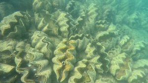
The next morning, we took the dinghy over to an area that was home to a large group of clams. (Peter told us that a guy had seeded the clam patch in the 1980’s). Once we reached the clam area, the water was perfect, and we could see them just under the water. Most of them were open due to the sun, just amazing. But the tidal conditions weren’t quite right for snorkelling, so we took a quick tour around the nearby coral and bombie area before heading back to the boat to get ready for an island hike.
The island map wasn’t great, and it took us a while to find the track, but once we did, we made our way to the ruins of a stone shepherd’s hut. The track was similar to that of Dunk Island, lots of debris, rocks and roots with some sections overgrown. Concerningly, Katrina got a tick attached to her lower leg near her ankle, which Chloe managed to cleanly remove. Nearing the highest point of the island the track levelled out, and we walked along a path with tall grass on either side. Then the track gave way to a field dotted with large boulders, and stone cliffs that dropped into the sea below. With beautiful views across the ocean, we spotted two whales frolicking around a distance out from shore. Photo of the shepherd’s hut.

Returning to the boat and with high tide approaching, we prepped for the trip back to the clam patch. Peter, Chloe and Katrina all went in for a snorkel, Sandra stayed onboard the dinghy (the waters were a bit too deep and too far from shore for her liking). Once all were back on the dinghy, Sandra put the snorkel mask on, and leaning over the side of the dinghy got an amazing view of the clams and small fish darting here and there. A bit of an everything day, which is just how we like it. Photo below: part of the clam patch taken underwater by Peter using the GoPro.
Rattlesnake Island
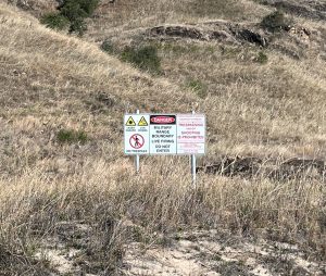
We left Orpheus Island at 0830 and whilst motor-sailing out of Pioneer Bay we sighted a solo humpback whale and 4 dolphins. What a great start to the day. We passed several islands of all shapes and sizes as we made our way to Rattlesnake Island for an overnight stopover, anchoring here by mid-afternoon. This island as well as Herald Island next door, nearby Cordelia Rocks and Acheron Island are collectively an Australian Defence Force military zone, though you are allowed to access these islands if no military activity is occurring. Us girls were happy to note that Peter had already checked that nothing was scheduled during our planned time here.
We were also fascinated by the name, since rattlesnakes are not native to Australia. Well Mr Google provided all we needed to know. The island was a spawning area for the elusive rock bass and if the island was named Red Bass Island the powers that be knew that they would be fished to extinction. In an effort to scare fishermen away the island was named Rattlesnake Island. The fact there were no rattlesnakes on the island did not sway the naming of the island as such. So, there you go. We can only assume it worked and hope that schools of rock bass can still be found in the surrounding waters.
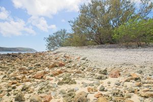
Once anchored, we took the dinghy to the beach and immediately spotted a large danger sign reflective of the military activities including laser guided bombs, but there was no sign of destruction or debris on this side of the island. A reef hugs the shoreline with large grey and black rocks to the farthest end of the beach which then made way to a spit which stretched out to sea at low tide. The beach itself was littered with lovely and unusual shells with many intact, as well as bleached pieces of coral and small rocks. We had the island to ourselves, so we made the most of our time here fossicking around, paddling in the shallows, enjoying the sunshine and the peacefulness.

Next morning we motored between Rattlesnake and Herald Islands on our way to Magnetic Island. Strong winds and chop made for a slow and uncomfortable passage with Peter hand steering all the way. We approach Magnetic Island from the north, and conditions improved when we reached the lee of the island and anchored in White Lady Bay. We missed lunch so sundowners were the go, as we all settled in for a relaxing evening.
Magnetic (Maggie) Island
Next morning we took the dinghy over to the beach and the main tourist strip of the island. But that’s not what caught our attention, there were a series of market stalls set up along the foreshore and us girls were all very happy browsing and chatting to the stall holders. Then we made our way to the beach on the eastern side of the bay to begin what became another marathon walk, 20,000+ steps in all*.
The walk was quite challenging in parts but so worth it. Lots of postcard worthy bays and views, clusters of towering rocks, remnants of a military outpost and radio installation, wallabies and two koala mums with their joeys -super cute. Our walk took us to:
- Radical Bay (Photo below)
- Coconut Bay
- Florence Bay
- Arthur Bay Lookout (Photo below)
- the Fort Walk,
- then back to the beach via Horseshoe Bay Road (Photo of Horseshoe Bay below).


While we were here we noted about half a dozen large birds that circled above our anchorage looking for a feed. We were able to identify a majestic white tailed sea eagle and a brahminy kite. Two trawlers anchored a short distance behind us at White Lady Bay, and on their return each morning birds of all shapes and sizes would flock to them and sit on their spreaders waiting for the off cuts of their catch.
*There is a public bus that has access by road to the eastern and southern areas of the island. The western and northern parts are only accessible via foot, and both are quite a hoof from the main town and island resorts. It is also possible to bring your own car or a hire car to the island via a car ferry which departs from Townsville. Sealink passenger ferries also run regularly to the island from its terminal near the commercial port at Townsville.
Thank you so much for taking the time out of your day to read our blog. We’ll leave you with this quote:
‘Travel not to find yourself but to remember who you have been along the way‘
(Author Unknown)
For ease of location, we have grouped all the anchorages and moorings we utilised for the Cairns to Townsville leg into one blog. Refer below or click this link https://seagoddessadventures.com/cairns-to-townsville-anchorages/
A separate blog provides a review of Breakwater Marina, Townsville. Refer below or click this link https://seagoddessadventures.com/breakwater-marina/